Home > Science > Space Exploration > Planets > Earth
Globe Showing Europe, True Colour Satellite Image Of The Earth Showing Greenland, North Pole, Europe

![]()
Wall Art and Photo Gifts from Design Pics
Globe Showing Europe, True Colour Satellite Image Of The Earth Showing Greenland, North Pole, Europe
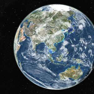
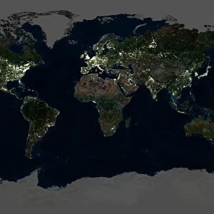
Globe Showing Europe, True Colour Satellite Image. True colour satellite image of the Earth showing Greenland, the North Pole and Europe, with cloud coverage. This image in orthographic projection was compiled from data acquired by LANDSAT 5 & 7 sat
Design Pics offers Distinctively Different Imagery representing over 1,500 contributors
Media ID 24586957
© UIG / Design Pics
Atlantic Ocean Daniel Earth Earth Science Environment Geographic Illustration Globe Greenland Mediterranean Sea Northern Africa Planet Planet Earth Relief Russelman Satellite Image Sciences Space Uig Premium 1 Uig1 Satellite And Aerial World
FEATURES IN THESE COLLECTIONS
> Aerial Photography
> Related Images
> Design Pics
> Design Pics Art
> Design Pics
> Universal Images Group
> Design Pics
> Update - March 23, 2022
> Maps and Charts
> World
> North America
> Greenland
> Maps
> North America
> Greenland
> Related Images
> Science
> Space Exploration
> Planets
> Earth
EDITORS COMMENTS
This print showcases a true color satellite image of our beautiful planet Earth, specifically focusing on Greenland, the North Pole, and Europe. With intricate details and cloud coverage visible, this image was compiled using data acquired by LANDSAT 5 & 7 satellites. The orthographic projection used in this illustration provides a unique perspective of our world. The vibrant colors highlight the diverse landscapes found across these regions. From the icy expanses of Greenland to the lush forests and bustling cities of Europe, this image captures the essence of our planet's natural beauty. As you gaze at this mesmerizing print, take a moment to appreciate the vastness and interconnectedness of our global environment. The Atlantic Ocean stretches out before your eyes while Northern Africa and the Mediterranean Sea add depth to this panoramic view. Created by Daniel Russelman with expertise in earth sciences and geographic illustrations, this print is not just an artistic representation but also serves as a valuable educational tool. It allows us to explore different parts of our world from afar while reminding us that we are all inhabitants sharing one home - Planet Earth
MADE IN THE USA
Safe Shipping with 30 Day Money Back Guarantee
FREE PERSONALISATION*
We are proud to offer a range of customisation features including Personalised Captions, Color Filters and Picture Zoom Tools
SECURE PAYMENTS
We happily accept a wide range of payment options so you can pay for the things you need in the way that is most convenient for you
* Options may vary by product and licensing agreement. Zoomed Pictures can be adjusted in the Cart.