Home > Aerial Photography > Related Images
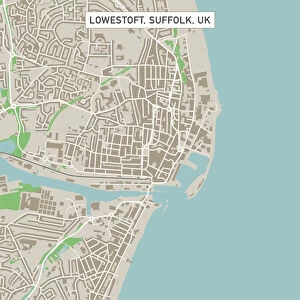
Meridian Idaho US City Street Map

![]()
Wall Art and Photo Gifts from Fine Art Storehouse
Meridian Idaho US City Street Map
Vector Illustration of a City Street Map of Meridian, Idaho, USA. Scale 1:60, 000.
All source data is in the public domain.
U.S. Geological Survey, US Topo
Used Layers:
USGS The National Map: National Hydrography Dataset (NHD)
USGS The National Map: National Transportation Dataset (NTD)
Unleash your creativity and transform your space into a visual masterpiece!
Frank Ramspott
Media ID 15054953
© Frank Ramspott, all rights reserved
Aerial View City Map Computer Graphic Directly Above Downtown District Gray Idaho Road Map Text Digitally Generated Image Meridian White Color
FEATURES IN THESE COLLECTIONS
> Aerial Photography
> Related Images
> Arts
> Contemporary art
> Digital artwork
> Street art
> Arts
> Landscape paintings
> Waterfall and river artworks
> River artworks
> Arts
> Portraits
> Pop art gallery
> Street art portraits
> Arts
> Street art graffiti
> Digital art
> Digital paintings
> Arts
> Street art graffiti
> Digital art
> Vector illustrations
> Fine Art Storehouse
> Map
> Street Maps
> Fine Art Storehouse
> Map
> USA Maps
> Maps and Charts
> Geological Map
> Maps and Charts
> Related Images
> North America
> United States of America
> Idaho
> Related Images
> North America
> United States of America
> Lakes
> Related Images
EDITORS COMMENTS
This print showcases a meticulously detailed city street map of Meridian, Idaho in the United States. Created as a vector illustration, this artwork offers an accurate representation of the city's downtown district, complete with its beautiful lake and river. The scale of 1:60,000 ensures that every street and road is clearly depicted for easy navigation. The source data used to create this stunning piece is all in the public domain, originating from reputable sources such as the U. S. Geological Survey (USGS) and their National Map datasets including the National Hydrography Dataset (NHD) and National Transportation Dataset (NTD). This guarantees reliability and accuracy in capturing Meridian's geography. Designed by Frank Ramspott using computer graphics techniques, this digitally generated image boasts vibrant colors of gray, blue, and white that bring life to the map. The aerial view perspective allows viewers to appreciate Meridian from directly above, providing a unique visual experience. Perfect for enthusiasts of cartography or those with a special connection to Meridian, this art print serves as both an aesthetically pleasing decoration and a functional tool for exploring the city's streets. With no people present in the image itself, it focuses solely on showcasing Meridian's physical geography through expertly crafted design elements.
MADE IN THE USA
Safe Shipping with 30 Day Money Back Guarantee
FREE PERSONALISATION*
We are proud to offer a range of customisation features including Personalised Captions, Color Filters and Picture Zoom Tools
SECURE PAYMENTS
We happily accept a wide range of payment options so you can pay for the things you need in the way that is most convenient for you
* Options may vary by product and licensing agreement. Zoomed Pictures can be adjusted in the Cart.