Home > Arts > Artists > W > Frederick Walker
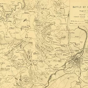
Map of the Battle of Courcelles, 14 August 1870, (c1872). Creator: R. Walker
. Creator: R. Walker")
![]()
Wall Art and Photo Gifts from Heritage Images
Map of the Battle of Courcelles, 14 August 1870, (c1872). Creator: R. Walker
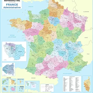
Map of the Battle of Courcelles, 14 August 1870, (c1872). Map: Drawn under the Superintendance of Captain Hozier, showing the enemy positions. The Battle of Borny-Colombey, (also known as the Battle of Colombey-Nouilly or the Battle of Courcelles), was fought near Metz (in France) between the French under Francois Bazaine, and the Prussians under Prince Frederick Charles. From " The Franco-Prussian War: its causes, incidents and consequences", Volume I, by Captain H M Hozier. [William Mackenzie, London, 1872]
Heritage Images features heritage image collections
Media ID 19778777
© The Print Collector/Heritage Images
1870 1871 Bamp W Franco Prussian War Front Line Frontline H M Hozier Henry Montague Henry Montague Hozier Hozier Lines Lorraine Mackenzie Metz Mosel Moselle Prussian Army R Walker River Mosel Robert Walker Sir Henry Montagu Hozier Walker William Mackenzie Battlefield Siege Of Metz
FEATURES IN THESE COLLECTIONS
> Arts
> Artists
> C
> William Charles
> Arts
> Artists
> M
> Frederick Mackenzie
> Arts
> Artists
> W
> Charles White
> Arts
> Artists
> W
> Frederick Walker
> Arts
> Artists
> W
> Robert Walker
> Arts
> Artists
> W
> Robert White
> Arts
> Artists
> W
> William White
> Arts
> Landscape paintings
> Waterfall and river artworks
> River artworks
> Europe
> France
> Canton
> Moselle
EDITORS COMMENTS
This print showcases a historical map titled "Map of the Battle of Courcelles, 14 August 1870". Created by R. Walker in approximately 1872, this map was drawn under the supervision of Captain Hozier to display the enemy positions during the Battle of Borny-Colombey. This significant battle took place near Metz, France, between French forces led by Francois Bazaine and Prussian forces commanded by Prince Frederick Charles. The detailed map captures the strategic locations and geographical features surrounding Metz, including cities, rivers, towns, and country borders. It provides valuable insights into the warfare tactics employed during this intense conflict that occurred in the late 19th century. This print is sourced from "The Franco-Prussian War: its causes, incidents and consequences". Volume I written by Captain H M Hozier in 1872. Published by William Mackenzie in London, it offers a comprehensive account of this historic war. With its intricate details and monochromatic aesthetic, this image transports viewers back to a pivotal moment in history when nations clashed on European soil. The print collector has preserved this piece as an invaluable resource for understanding military strategies employed during battles like Courcelles.
MADE IN THE USA
Safe Shipping with 30 Day Money Back Guarantee
FREE PERSONALISATION*
We are proud to offer a range of customisation features including Personalised Captions, Color Filters and Picture Zoom Tools
SECURE PAYMENTS
We happily accept a wide range of payment options so you can pay for the things you need in the way that is most convenient for you
* Options may vary by product and licensing agreement. Zoomed Pictures can be adjusted in the Cart.


![The House with the Inscription [left], 1741. Creator: Canaletto](/sq/731/house-inscription-left-1741-creator-21234887.jpg.webp)