Home > Asia > Iran > Lakes > Caspian Sea
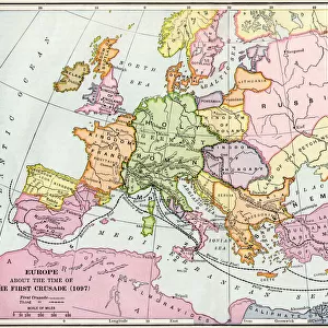
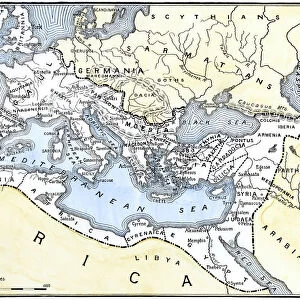
The Omayyad Caliphate v. Byzantine Empire, circa 748 A. D. c1915. Creator: Emery Walker Ltd

![]()
Wall Art and Photo Gifts from Heritage Images
The Omayyad Caliphate v. Byzantine Empire, circa 748 A. D. c1915. Creator: Emery Walker Ltd
The Omayyad Caliphate v. Byzantine Empire, circa 748 A.D. c1915. Map of the Mediterranean and Near East, showing the Kingdom of Mohammed, Additions under the Caliphs, and the boundary at death of Walid. From " The Caliphs Last Heritage, a short history of the Turkish Empire" by Lt.-Col. Sir Mark Sykes. [Macmillan & Co, London, 1915]
Heritage Images features heritage image collections
Media ID 19658815
© The Print Collector/Heritage Images
6th Baronet 8th Century Ancient World Arabia Armenia Armenian Black Sea Boutall Boutall Walker Byzantine Empire Byzantium Caliphate Caspian Sea Caucasus Caucasus Asia Cockerell Cockerell Walker Colonel Sir Tatton Benvenuto Mark Sykes Constantinople Damascus Damascus Syria Emery Emery Walker Limited Emery Walker Ltd Euphrates Iran Iranian Islamic State Istanbul Kurdistan Lieutenant Colonel Sir Mark Sykes Macmillan Macmillan And Co Macmillan Publishers Macmillan Publishers Ltd Mark Mark Sykes Mediterranean Sea Persia Persian Publishers Macmillan River Euphrates River Tigris Sir Mark Sykes Stamboul State Sykes Sykes Mark Sykes Mark Sir Sykes Tatton Benvenuto Mark Syria Tatton Benvenuto Mark Tatton Benvenuto Mark Sykes Tigris Tigris River Turkey Turkish Walker Walker Amp Walker And Boutall Walker And Cockerell Walker Boutall Walker Cockerell Walker Emery Ltd Mizraim
FEATURES IN THESE COLLECTIONS
> Africa
> Egypt
> Related Images
> Arts
> Artists
> S
> Syrian Syrian
> Asia
> Armenia
> Related Images
> Asia
> Iran
> Lakes
> Caspian Sea
> Asia
> Iran
> Related Images
EDITORS COMMENTS
This photo print, titled "The Omayyad Caliphate v. Byzantine Empire, circa 748 A. D. c1915" takes us back in time to a crucial period in history. Created by Emery Walker Ltd, this map showcases the Mediterranean and Near East region during the reign of the Omayyad Caliphate. Intricately detailed, the map illustrates the vast territories controlled by Mohammed's Kingdom and subsequent additions made under various caliphs. It also highlights the boundary at Walid's death, providing valuable insights into the expansion and evolution of this powerful Islamic state. Accompanying this historical snapshot is an excerpt from Lt. -Col. Sir Mark Sykes' book "The Caliphs Last Heritage: A Short History of The Turkish Empire". Published in 1915 by Macmillan & Co. , London, it offers readers a deeper understanding of this significant era. As we gaze upon this image, our minds are transported to ancient lands such as Arabia, Armenia, Egypt, Iran (Persia), Kurdistan, Syria (Damascus), and Constantinople (Istanbul). We can almost feel the weight of history on our shoulders as we contemplate how these empires shaped their respective regions. Emery Walker Ltd has masterfully captured not only geographical features but also cultural intersections that defined civilizations during that time. This print serves as a testament to their dedication to preserving historical heritage for generations to come.
MADE IN THE USA
Safe Shipping with 30 Day Money Back Guarantee
FREE PERSONALISATION*
We are proud to offer a range of customisation features including Personalised Captions, Color Filters and Picture Zoom Tools
SECURE PAYMENTS
We happily accept a wide range of payment options so you can pay for the things you need in the way that is most convenient for you
* Options may vary by product and licensing agreement. Zoomed Pictures can be adjusted in the Cart.