Home > Arts > Artists > A > John White Alexander
The War Map of Western Europe, 1915. Creator: Unknown

![]()
Wall Art and Photo Gifts from Heritage Images
The War Map of Western Europe, 1915. Creator: Unknown
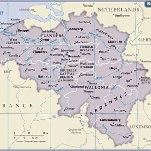
The War Map of Western Europe, 1915. Following the outbreak of war in August 1914, the German Army opened the Western Front by invading Luxembourg and Belgium and gaining military control of important industrial regions in France. From " The War Illustrated Album De Luxe - Volume I. The First Phase", edited by J. A. Hammerton. [The Amalgamated Press, Limited, London, 1915]
Heritage Images features heritage image collections
Media ID 19661375
© The Print Collector/Heritage Images
Advance Album Amalgamated Press Amalgamated Press Limited Amalgamated Press Ltd Brussels Brussels Belgium First Phase Hammerton Hammerton J A Hammerton Ja Hammerton Sir John Alexander Invasion J A Hammerton Ja Hammerton John Hammerton London England United Kingdom North Sea Paris Ile De France France Sir John Alexander Sir John Alexander Hammerton Sir John Hammerton Strategic Strategy The Amalgamated Press The War Illustrated West Western Western Front
FEATURES IN THESE COLLECTIONS
> Arts
> Artists
> A
> John White Alexander
> Arts
> Artists
> W
> John White
> Europe
> Belgium
> Related Images
> Europe
> France
> Paris
> Maps
The War Map of Western Europe, 1915
EDITORS COMMENTS
is a captivating print that takes us back to the tumultuous times of the First World War. Created by an unknown artist, this historical artifact provides a glimpse into the strategic landscape of Europe during one of its darkest periods. The map showcases the German Army's invasion and military control over Luxembourg, Belgium, and important industrial regions in France. It highlights how these advances opened up the Western Front and set the stage for intense conflict between opposing forces. With its black and white composition, this print exudes a sense of gravity and seriousness befitting such a significant moment in history. The intricate details on display allow viewers to trace geographical features like coastlines and major cities such as Brussels and Paris. As we observe this map from more than a century ago, it serves as a reminder of the immense human cost incurred during those years. It prompts us to reflect on the bravery displayed by soldiers who fought valiantly along these frontlines. Preserved within "The War Illustrated Album De Luxe - Volume I" edited by J. A. Hammerton, this print stands as an invaluable piece of historical documentation. Its significance lies not only in its depiction of military strategy but also in its ability to transport us back to an era defined by sacrifice, resilience, and hope for peace amidst chaos.
MADE IN THE USA
Safe Shipping with 30 Day Money Back Guarantee
FREE PERSONALISATION*
We are proud to offer a range of customisation features including Personalised Captions, Color Filters and Picture Zoom Tools
SECURE PAYMENTS
We happily accept a wide range of payment options so you can pay for the things you need in the way that is most convenient for you
* Options may vary by product and licensing agreement. Zoomed Pictures can be adjusted in the Cart.