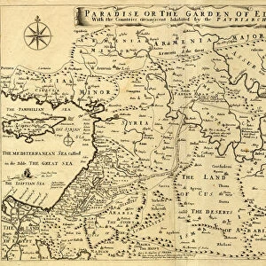
1650, Fuller Map of Jerusalem, Israel, Palestine, Holy Land, topography, cartography

![]()
Wall Art and Photo Gifts from Liszt Collection
1650, Fuller Map of Jerusalem, Israel, Palestine, Holy Land, topography, cartography
1650, Fuller Map of Jerusalem, Israel, Palestine, Holy Land
Liszt Collection of nineteenth-century engravings and images to browse and enjoy
Media ID 14004435
© Artokoloro Quint Lox Limited
1650 Holy Land Antique Map Latitude Longitude Mappa Mundi Old Antique Plan Old Antique View Ols Antique Map Rare Old Maps Topo
EDITORS COMMENTS
This print showcases the intricate and detailed 1650 Fuller Map of Jerusalem, Israel, Palestine, and the Holy Land. A true masterpiece of cartography, this vintage map offers a fascinating glimpse into the topography and geography of this historically significant region. The map's rich illustration transports us back in time to an era when exploration and discovery were at their peak. Its carefully plotted grid lines reveal latitude and longitude coordinates, highlighting its accuracy even by today's standards. The geometric precision employed in creating this ancient artifact is truly remarkable. As we delve into its historical significance, we are reminded of the countless journeys taken by explorers who relied on maps like these for navigation. This rare old map not only serves as a valuable tool but also as a work of art that captures our imagination. The aged appearance adds to its charm, evoking a sense of nostalgia for times long gone. It invites us to explore the past through its decorative features while appreciating the craftsmanship involved in producing such an exquisite piece. Whether you are a history enthusiast or simply captivated by antique maps, this print from Liszt Collection allows you to bring home a slice of world history. Display it proudly as both an educational resource and a stunning conversation starter about our planet's diverse past.
MADE IN THE USA
Safe Shipping with 30 Day Money Back Guarantee
FREE PERSONALISATION*
We are proud to offer a range of customisation features including Personalised Captions, Color Filters and Picture Zoom Tools
SECURE PAYMENTS
We happily accept a wide range of payment options so you can pay for the things you need in the way that is most convenient for you
* Options may vary by product and licensing agreement. Zoomed Pictures can be adjusted in the Cart.