Home > Europe > United Kingdom > England > London > Boroughs > Havering
Havering RM5 2 Map

![]()
Wall Art and Photo Gifts from Map Marketing
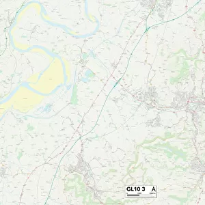
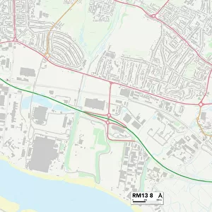
Havering RM5 2 Map
Postcode Sector Map of Havering RM5 2
Media ID 19979133
Aragon Close Browning Close Carter Close Carter Drive Clitheroe Road Downham Close Eaton Drive Firbank Road Fox Close Frinton Road Fry Close Hamlet Close Hamlet Road Havering Hollybush Close Kingshill Avenue Larchwood Avenue Lodge Lane Lynwood Close Lynwood Drive Melville Road Miller Close Owen Close Pennington Close Providence Place Riversdale Road St Johns Road Taylor Close Victoria Avenue Walton Road Wensley Close
FEATURES IN THESE COLLECTIONS
> Arts
> Artists
> B
> John Brown
> Arts
> Artists
> C
> John Carter
> Arts
> Artists
> C
> John Collier
> Arts
> Artists
> F
> John Field
> Arts
> Artists
> H
> John Hillers
> Arts
> Artists
> H
> John Hills
> Arts
> Artists
> L
> John Lodge
> Arts
> Artists
> M
> John Miller
> Europe
> United Kingdom
> England
> London
> Boroughs
> Havering
> Map Marketing
> Postcode Sector Maps
> RM - Romford
MADE IN THE USA
Safe Shipping with 30 Day Money Back Guarantee
FREE PERSONALISATION*
We are proud to offer a range of customisation features including Personalised Captions, Color Filters and Picture Zoom Tools
SECURE PAYMENTS
We happily accept a wide range of payment options so you can pay for the things you need in the way that is most convenient for you
* Options may vary by product and licensing agreement. Zoomed Pictures can be adjusted in the Cart.