Home > Europe > France > Canton > Landes
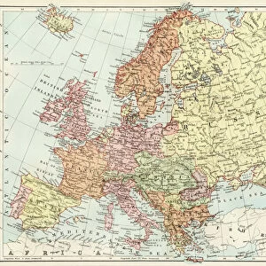
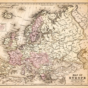
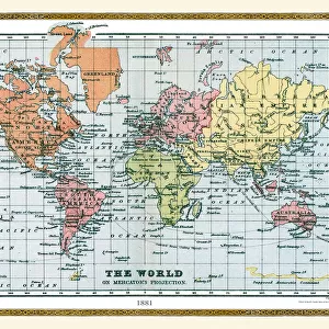
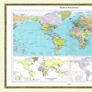
Old Map of The World 1881

![]()
Wall Art and Photo Gifts from MapSeeker
Old Map of The World 1881
Irish Land War (1879-1882); home rule movement led by Parnell. End of First Boer War (1880-1881). French establish a protectorate in Tunisia. President Garfield (USA) and Tsar Alexander II (Russia) assassinated. Serbia and Romania independent from the Ottoman Empire
Welcome to the Mapseeker Image library and enter an historic gateway to one of the largest on-line collections of Historic Maps, Nostalgic Views, Vista's and Panorama's from a World gone by.
Media ID 20347394
© Collins Bartholomew - Mapseeker Publishing Ltd
Map Of The World Old Map Of The World The World World Map
FEATURES IN THESE COLLECTIONS
> Africa
> Tunisia
> Related Images
> Europe
> France
> Canton
> Landes
> Europe
> Republic of Ireland
> Maps
> Europe
> Romania
> Related Images
> MapSeeker
> Maps Showing the World
> Maps of The World by Year PORTFOLIO
EDITORS COMMENTS
This print showcases an extraordinary piece of history - an old map of the world from 1881. A visual time capsule, this map encapsulates a momentous era marked by significant global events and political shifts. The Irish Land War (1879-1882) and the home rule movement led by Parnell are depicted, reflecting Ireland's struggle for independence during this period. The aftermath of the First Boer War (1880-1881), which saw British forces clash with Boer settlers in South Africa, is also captured on this map. It serves as a reminder of the tensions that shaped colonial relations at the time. Additionally, it highlights France's establishment of a protectorate in Tunisia, signifying European powers' growing influence over African territories. Tragically, two prominent leaders met their untimely demise during this period - President Garfield of the United States and Tsar Alexander II of Russia were both assassinated. Their deaths left lasting impacts on their respective nations and reverberated across international politics. Furthermore, Serbia and Romania's emergence as independent states from under Ottoman Empire rule is illustrated here. This historical turning point reflects a wave of nationalism sweeping through Eastern Europe during the late 19th century. As we gaze upon this ancient cartographic treasure, we are transported back to a time when borders were shifting, empires were crumbling, and nations were fighting for self-determination. It reminds us that our world has always been in flux; constantly evolving through triumphs
MADE IN THE USA
Safe Shipping with 30 Day Money Back Guarantee
FREE PERSONALISATION*
We are proud to offer a range of customisation features including Personalised Captions, Color Filters and Picture Zoom Tools
SECURE PAYMENTS
We happily accept a wide range of payment options so you can pay for the things you need in the way that is most convenient for you
* Options may vary by product and licensing agreement. Zoomed Pictures can be adjusted in the Cart.