Fraud Blocker Skip to main content

Home > Asia > Turkey > Related Images
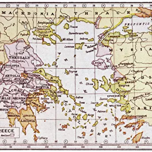
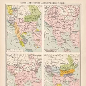
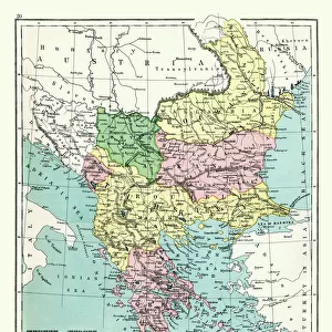
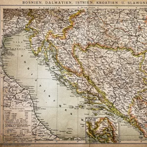
Map of Greece, 1792

Map of Greece, 1792


Canvas Prints
Fine Art Prints
Metal Prints
Home Decor


We accept all major credit cards

Mary Evans Prints Online

Wall Art and Photo Gifts from Mary Evans Picture Library

Map of Greece, 1792

Map of Greece and Greek islands plus Romania (which appears on this map to be incorrectly labelled or positioned south of Bulgaria), Macedonia, Albania and parts of Turkey and Italy. (Detail of image 10074527) Date: 1792

Mary Evans Picture Library makes available wonderful images created for people to enjoy over the centuries

Media ID 7188023

© Mary Evans Picture Library 2015 - https://copyrighthub.org/s0/hub1/creation/maryevans/MaryEvansPictureID/10527528

1790s 1792 Albania Macedonia Maps Romania


FEATURES IN THESE COLLECTIONS

> Asia > Turkey > Related Images

> Europe > Albania > Maps

> Europe > Albania > Posters

> Europe > Albania > Related Images

> Europe > Bulgaria > Maps

> Europe > Bulgaria > Posters

> Europe > Bulgaria > Related Images

> Europe > Greece > Maps

> Europe > Greece > Posters

> Europe > Greece > Related Images


MADE IN THE USA
Safe Shipping with 30 Day Money Back Guarantee

FREE PERSONALISATION*
We are proud to offer a range of customisation features including Personalised Captions, Color Filters and Picture Zoom Tools

SECURE PAYMENTS
We happily accept a wide range of payment options so you can pay for the things you need in the way that is most convenient for you

* Options may vary by product and licensing agreement. Zoomed Pictures can be adjusted in the Cart.


redeem
Beautiful Photo Prints and Gifts
image
Professionally Printed
inventory
Photo Prints are in stock
thumb_up
Professional quality finish
diamond
Made with high-grade materials
inventory_2
Carefully packed to aid safe arrival


Related Images


Map of Greece - Vector
Map of Ancient Greece
Romania country map
Romania country map
Map of Romania, Serbia, Montenegro, and Bulgaria 19th Century
Europe Map C1914
Europe Map C1914
Map of the Balkans, highlighting Greek and Turkish territory
Historical map of the Oriental part of world
Ottoman Empire, 14th-19th century, lithograph, published in 1878
Albania - Alliance-Santi - Quaranta - General view
Italy Map - illustration
Antique map of Greece, Romania, Bulgaria, 1897, late 19th Century
Map of the Kingdom of Hungary, 1742 (hand coloured engraving)

+

Shipping

+

Choices

+

Reviews

+

Guaranteed


Related Collections


Turkey Related Images
Browse 15,849 Prints
Albania Related Images
Browse 936 Prints
Bulgaria Related Images
Browse 1,849 Prints
Greece Related Images
Browse 36,234 Prints
Maps
Maps
Browse 33 Prints
Maps
Maps
Browse 69 Prints
Maps
Maps
Browse 1,165 Prints
Posters
Posters
Browse 910 Prints
Posters
Posters
Browse 1,803 Prints
Posters
Posters
Browse 34,435 Prints