Home > Universal Images Group (UIG) > Art > Painting, Sculpture & Prints > Cartography
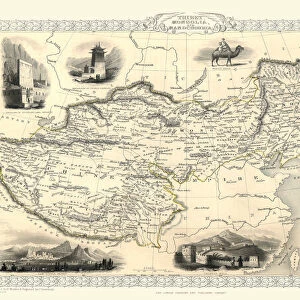
General map of China, Chinese Tartary and Tibet, by Jean-Baptiste Bourguignon d Anville, copperplate printed in Paris, 1734

![]()
Wall Art and Photo Gifts from Universal Images Group (UIG)
General map of China, Chinese Tartary and Tibet, by Jean-Baptiste Bourguignon d Anville, copperplate printed in Paris, 1734
Cartography, 18th century. General map of China, Chinese Tartary and Tibet, produced on special paper by the Jesuits. Created by Jean-Baptiste Bourguignon d Anville, using Antoine Humblots scrolls. Paris, 1734. Copperplate. 49 x 70 cm
Universal Images Group (UIG) manages distribution for many leading specialist agencies worldwide
Media ID 9502893
© DEA PICTURE LIBRARY
18th Century China Copperplate Direction Guidance Tibet Western Script Inner Mongolia
MADE IN THE USA
Safe Shipping with 30 Day Money Back Guarantee
FREE PERSONALISATION*
We are proud to offer a range of customisation features including Personalised Captions, Color Filters and Picture Zoom Tools
SECURE PAYMENTS
We happily accept a wide range of payment options so you can pay for the things you need in the way that is most convenient for you
* Options may vary by product and licensing agreement. Zoomed Pictures can be adjusted in the Cart.