Home > Europe > United Kingdom > England > Lancashire > Wyre
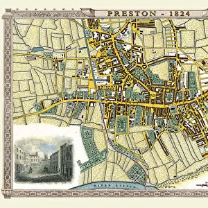
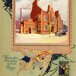
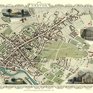
Old Map of Preston 1851 by John Tallis

![]()
Wall Art and Photo Gifts from MapSeeker
Old Map of Preston 1851 by John Tallis
The River Ribble in Lancashire by John Tallis 1851 with a most rural presentation of Preston surrounded by numerous meadows and open fields. The plan is beautifully finished with seven illustrations. These illustrations are the Ribble from Avenham Walk, Grammar School, Mechanics Institution, North Union Railway Station, Literacy and Philosophical Institution, Preston and Wyre Viaduct and St Peters Church
Welcome to the Mapseeker Image library and enter an historic gateway to one of the largest on-line collections of Historic Maps, Nostalgic Views, Vista's and Panorama's from a World gone by.
Media ID 20347618
Historic Map John Tallis John Tallis Map Old Town Plan Tallis Map Preston
FEATURES IN THESE COLLECTIONS
> Animals
> Mammals
> Muridae
> Peters Mouse
> Arts
> Artists
> F
> John Field
> Arts
> Artists
> T
> John Tallis
> Europe
> United Kingdom
> England
> Lancashire
> Church
> Europe
> United Kingdom
> England
> Lancashire
> Preston
> Europe
> United Kingdom
> England
> Lancashire
> Related Images
> Europe
> United Kingdom
> England
> Lancashire
> Ribble
> Europe
> United Kingdom
> England
> Lancashire
> Wyre
> Maps and Charts
> Related Images
> MapSeeker
> British Town And City Plans
> English & Welsh PORTFOLIO
> Popular Themes
> Railway Posters
EDITORS COMMENTS
This print showcases the "Old Map of Preston 1851" by John Tallis, offering a glimpse into the rich history and rural charm of this Lancashire town. The map depicts Preston surrounded by vast meadows and open fields, presenting a picturesque view of the area as it was in the mid-19th century. What sets this plan apart is its exquisite craftsmanship, with seven beautifully illustrated landmarks adorning its borders. These illustrations include scenes such as the serene Ribble from Avenham Walk, showcasing nature's tranquility; the Grammar School and Mechanics Institution, representing education and knowledge; North Union Railway Station symbolizing progress through transportation; Literacy and Philosophical Institution highlighting intellectual pursuits; Preston and Wyre Viaduct displaying architectural marvels; and St Peters Church standing tall as a spiritual beacon. As you explore this historic map of Preston, you can't help but be transported back in time to an era where simplicity met grandeur. It offers a unique perspective on how this city has evolved over centuries while still retaining its essence. Whether you are a history enthusiast or simply appreciate artistry in cartography, this print serves as an enchanting window into Preston's past. It captures not only geographical details but also tells stories of growth, culture, and community that have shaped this remarkable place we know today as Preston.
MADE IN THE USA
Safe Shipping with 30 Day Money Back Guarantee
FREE PERSONALISATION*
We are proud to offer a range of customisation features including Personalised Captions, Color Filters and Picture Zoom Tools
SECURE PAYMENTS
We happily accept a wide range of payment options so you can pay for the things you need in the way that is most convenient for you
* Options may vary by product and licensing agreement. Zoomed Pictures can be adjusted in the Cart.