Iceland, satellite image

![]()
Wall Art and Photo Gifts from Science Photo Library
Iceland, satellite image
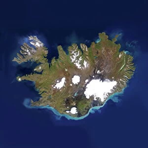
Iceland, satellite image. North is at top. Ice and snow are seen on Iceland (centre) and Eastern Greenland (upper left). Algal blooms and sediment from river run-off discolours the water around Iceland. Ice floes are visible off Eastern Greenland, along with ice in the coastal inlets. Image data obtained on 12 July 2012, with the MODIS (Moderate Resolution Imaging Spectroradiometer) sensor on one of NASAs Earth Observing System satellites (Terra and Aqua)
Science Photo Library features Science and Medical images including photos and illustrations
Media ID 9240947
© UNIVERSITY OF DUNDEE/SCIENCE PHOTO LIBRARY
2012 Aqua Arctic Atlantic Cloud Clouds Earth Observation Earth Observing System Earth Science Earth Sciences From Space Greenland Iceland Island Land Modis Satellite Satellite Image Snow Terra
MADE IN THE USA
Safe Shipping with 30 Day Money Back Guarantee
FREE PERSONALISATION*
We are proud to offer a range of customisation features including Personalised Captions, Color Filters and Picture Zoom Tools
SECURE PAYMENTS
We happily accept a wide range of payment options so you can pay for the things you need in the way that is most convenient for you
* Options may vary by product and licensing agreement. Zoomed Pictures can be adjusted in the Cart.