Home > Arts > Photorealistic artworks > Detailed art pieces > Masterful detailing in art
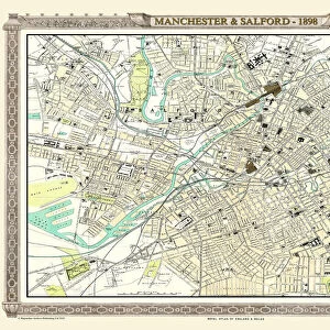
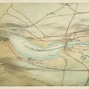
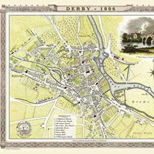
Old Map of the Great Central Railway and its Connections 1903

![]()
Wall Art and Photo Gifts from MapSeeker
Old Map of the Great Central Railway and its Connections 1903
This is a colourful and detailed reproduction map of " The Great Central Railway 1903" showing the lines and stations, with enlarged section showing the Northern Manufacturing Districts. Visual Application of colour differentiates manufacturing districts, agricultural districts, upland pasture and moorland. The map also shows the principal canals that were by now in decline due to the success of the railways. Shipping connections are also marked with distances from principal sea ports
Welcome to the Mapseeker Image library and enter an historic gateway to one of the largest on-line collections of Historic Maps, Nostalgic Views, Vista's and Panorama's from a World gone by.
Media ID 20348221
© Mapseeker Publishing Ltd
Historic Railway Map Old Railway Map Railway Map Great Central Railway
FEATURES IN THESE COLLECTIONS
> Arts
> Photorealistic artworks
> Detailed art pieces
> Masterful detailing in art
> Popular Themes
> Railway Posters
EDITORS COMMENTS
This vibrant and intricate reproduction map, titled "Old Map of the Great Central Railway and its Connections 1903" takes us back in time to explore the extensive railway network of the early 20th century. The map showcases the lines and stations of "The Great Central Railway" providing a fascinating glimpse into transportation history. What sets this map apart is its attention to detail. With a closer look, we can see an enlarged section highlighting the Northern Manufacturing Districts. Through skillful use of color, differentiating manufacturing districts from agricultural areas, upland pastures, and moorlands becomes effortless. This visual application allows us to understand how various regions were interconnected by rail during that era. Furthermore, this historical gem also reveals another aspect of transportation: canals. While once vital for trade and transport, their decline is evident on this map due to the railways' growing success. Additionally, shipping connections are marked with distances from principal sea ports – showcasing how railways played a crucial role in connecting landlocked regions with international trade routes. Published by MapSeeker Publishing Ltd. , this print offers both railway enthusiasts and history buffs an opportunity to delve into the past while appreciating the artistry behind cartography. Whether you're interested in old railway maps or simply fascinated by our ever-evolving modes of transportation, this piece will undoubtedly spark curiosity about how our world has changed over time.
MADE IN THE USA
Safe Shipping with 30 Day Money Back Guarantee
FREE PERSONALISATION*
We are proud to offer a range of customisation features including Personalised Captions, Color Filters and Picture Zoom Tools
SECURE PAYMENTS
We happily accept a wide range of payment options so you can pay for the things you need in the way that is most convenient for you
* Options may vary by product and licensing agreement. Zoomed Pictures can be adjusted in the Basket.