Home > Europe > United Kingdom > England > Avon
Runnymede KT15 1 Map

![]()
Wall Art and Photo Gifts from Map Marketing
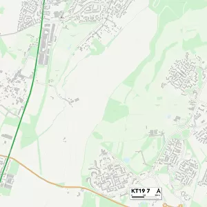
Runnymede KT15 1 Map
Postcode Sector Map of Runnymede KT15 1
Media ID 19973102
Audley Close Avon Close Barton Close Beech Grove Birchfield Close Brighton Road Burleigh Close Burleigh Road Chaucer Way Church Close Church Road Coombe Drive Dale Close Dickens Drive East Drive Farm Lane Furze Road Hartland Road High Street Hillside Gardens Holmwood Close Howards Lane Katherine Close Lane Close Leigh Close Lime Grove Marley Close Marsh Close Marsh Lane Meadow Way Milton Road Moore Close Oakhill Road Old Road Oliver Close Ongar Road Orchard Way Parklands Pear Tree Close Pear Tree Road Pine Court Runnymede Sandy Road School Lane Spinney Hill St Pauls Close Strawberry Fields The Glen The Grove The Ridings Weston Avenue Weston Close Woodlands Park Addlestone Redwoods
FEATURES IN THESE COLLECTIONS
> Europe
> United Kingdom
> England
> Avon
> Map Marketing
> Postcode Sector Maps
> KT - Kingston upon Thames
> Maps and Charts
> Related Images
MADE IN THE USA
Safe Shipping with 30 Day Money Back Guarantee
FREE PERSONALISATION*
We are proud to offer a range of customisation features including Personalised Captions, Color Filters and Picture Zoom Tools
SECURE PAYMENTS
We happily accept a wide range of payment options so you can pay for the things you need in the way that is most convenient for you
* Options may vary by product and licensing agreement. Zoomed Pictures can be adjusted in the Cart.