Home > Arts > Artists > O > Oceanic Oceanic
EXPL2A-00377

![]()
Wall Art and Photo Gifts from North Wind
EXPL2A-00377
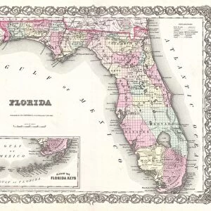
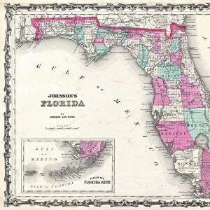
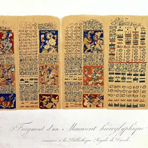
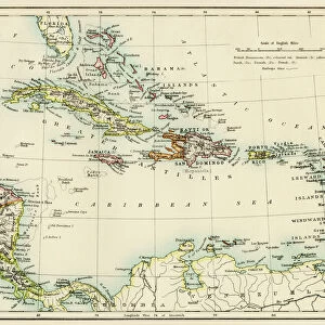
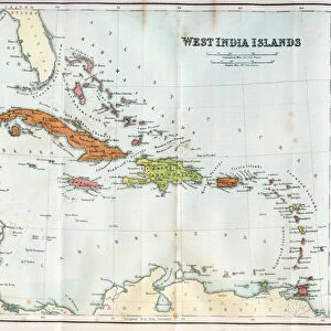
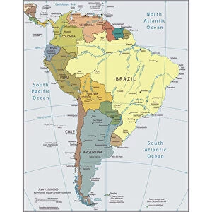
Chart of the West Indies sea depths and land elevations.
Printed color lithograph of a 19th-century illustration
North Wind Picture Archives brings history to life with stock images and hand-colored illustrations
Media ID 5881637
© North Wind Picture Archives
Caribbean Caribbean Sea Cartography Central America Chart Cuba Dominican Republic Florida Gulf Coast Gulf Of Mexico Haiti Hispaniola Island Isthmus Jamaica Latin America Mexican Mexico New World Ocean Panama Santo Domingo South America West Indies Bahamas Bermuda Colombia Columbia Costa Rica Guatemala Isthmus Of Panama Nicaragua Venezuela Yucatan
FEATURES IN THESE COLLECTIONS
> Arts
> Artists
> O
> Oceanic Oceanic
> Europe
> France
> Canton
> Landes
> Maps and Charts
> Related Images
> Maps and Charts
> World
> North America
> The Bahamas
> Maps
> North America
> The Bahamas
> Related Images
> North America
> Bermuda
> Maps
> North America
> Bermuda
> Related Images
> North America
> Costa Rica
> Maps
> North Wind Picture Archives
> Latin America:Caribbean
> North Wind Picture Archives
> Maps
EDITORS COMMENTS
This vintage print showcases the mesmerizing beauty of the West Indies, capturing both its sea depths and land elevations. The 19th-century illustration, presented as a printed color lithograph, takes us on a journey through history and geography. The chart encompasses an extensive area ranging from Florida to South America, including iconic islands such as Jamaica, Bermuda, Cuba, Hispaniola (Haiti and Dominican Republic), and the Bahamas. It also covers regions like Mexico, Panama, Guatemala, Colombia, Venezuela, Nicaragua, Costa Rica, and Yucatan. With intricate details and vibrant colors that bring it to life even after all these years have passed since its creation; this artwork is a testament to the artistry of cartography in depicting our world's wonders. As we explore this map-like image filled with historical significance and cultural richness associated with Latin America and the Caribbean region; it reminds us of the interconnectedness between nations across time. From trade routes to colonial influences or natural landmarks shaping civilizations - every inch of this chart tells stories waiting to be discovered. Whether you are an enthusiast of maritime history or simply captivated by artistic representations of our planet's landscapes; this print offers a glimpse into the past while celebrating the enduring allure of exploration.
MADE IN THE USA
Safe Shipping with 30 Day Money Back Guarantee
FREE PERSONALISATION*
We are proud to offer a range of customisation features including Personalised Captions, Color Filters and Picture Zoom Tools
SECURE PAYMENTS
We happily accept a wide range of payment options so you can pay for the things you need in the way that is most convenient for you
* Options may vary by product and licensing agreement. Zoomed Pictures can be adjusted in the Cart.