Home > Science > Space Exploration > Planets > Earth
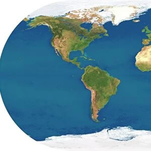
Earth from space, satellite image

![]()
Wall Art and Photo Gifts from Science Photo Library
Earth from space, satellite image
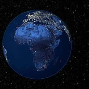
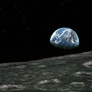
Earth from space. Satellite image showing North and South America as seen from 35, 000 kilometres above the Earths surface. North is at top and the Moon is at upper right. Clouds (white) are seen, as are seas and oceans (blue). Land cover ranges from vegetation such as forests and grassy plains (green) to arid areas such as deserts, mountains, and scrublands (brown). This image combines data from the Moderate Resolution Imaging Spectroradiometer (MODIS) instrument aboard NASAs Terra satellite and NOas Geostationary Operational Environmental Satellite (GOES)
Science Photo Library features Science and Medical images including photos and illustrations
Media ID 6303977
© NASA GODDARD SPACE FLIGHT CENTER (NASA-GSFC)/SCIENCE PHOTO LIBRARY
2002 Amazon Arid Atlantic Circle Circular Cloud Cloud Cover Clouds Cloudy Continent Continental Continents Day Time Desert Deserts Earth Observation Forest Forests From Space Globe Hemisphere Land Modis Moon Noaa Pacific Planetary Rain Forest Round Satellite Satellite Image Seas South America Stars Terra Vegetation World Rain Forests
FEATURES IN THESE COLLECTIONS
> Animals
> Echiniderms
> Sea Stars
> Related Images
> Animals
> Mammals
> Muridae
> Desert Mouse
> Animals
> Mammals
> Muridae
> Plains Mouse
> Animals
> Mammals
> Muridae
> Water Mouse
> Arts
> Artists
> O
> Oceanic Oceanic
> Arts
> Landscape paintings
> Forest and woodland scenes
> Forest artwork
> Europe
> France
> Canton
> Landes
> North America
> Related Images
> Posters
> Scientific Posters
> Science Photo Library
> Aerial and Satellite
> Science
> Space Exploration
> The Moon
> Science
> Space Exploration
> Planets
> Earth
EDITORS COMMENTS
This breathtaking print captures the beauty and vastness of our planet Earth as seen from space. Taken from a satellite positioned 35,000 kilometers above the Earth's surface, this image showcases North and South America in all their glory. The top of the frame reveals the North Pole while at the upper right corner, we catch a glimpse of our celestial neighbor, the Moon. The intricate details visible in this photograph are made possible by combining data from two powerful satellites: NASA's Terra satellite equipped with Moderate Resolution Imaging Spectroradiometer (MODIS) instrument and NOAA's Geostationary Operational Environmental Satellite (GOES). From lush green forests to arid deserts, mountains to scrublands, this image portrays Earth's diverse land cover with stunning accuracy. Clouds adorn the sky like fluffy white cotton balls while seas and oceans shimmer in various shades of blue. As we explore further into this mesmerizing scene, it becomes evident that our planet is teeming with life and natural wonders. The Amazon rainforest stands out prominently as one of Earth's most precious treasures. This snapshot serves as a reminder of how interconnected everything on our planet truly is - continents surrounded by vast bodies of water; circular patterns formed by cloud cover; day turning into night as stars begin to twinkle against an ink-black backdrop. It encapsulates both the fragility and resilience of our home in space – a testament to its enduring beauty for generations past, present, and future.
MADE IN THE USA
Safe Shipping with 30 Day Money Back Guarantee
FREE PERSONALISATION*
We are proud to offer a range of customisation features including Personalised Captions, Color Filters and Picture Zoom Tools
SECURE PAYMENTS
We happily accept a wide range of payment options so you can pay for the things you need in the way that is most convenient for you
* Options may vary by product and licensing agreement. Zoomed Pictures can be adjusted in the Cart.