Home > Europe > United Kingdom > England > London > Boroughs > Greenwich
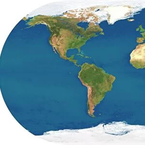
Earth, topographic and bathymetric map

![]()
Wall Art and Photo Gifts from Science Photo Library
Earth, topographic and bathymetric map
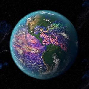
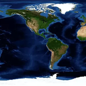
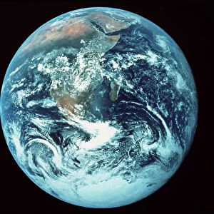
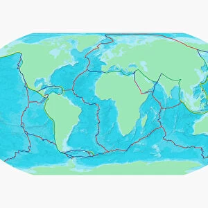
Earth, topographic and bathymetric map. This whole Earth map is centred on the Greenwich meridian, at zero degrees latitude. Highlands and lowlands of the continents are shown as ridges and flat areas, with Arctic and Antarctic ice in white. The seabed depth varies from shallow (light blue) on the continental shelves, to deep ocean basins (dark blue). Topographic and bathymetric data is usually gathered by using aerial and satellite imagery combined with radar and sonar mapping. The satellites in this case were NOas POES satellites
Science Photo Library features Science and Medical images including photos and illustrations
Media ID 1705101
© PLANETARY VISIONS LTD/SCIENCE PHOTO LIBRARY
Altimetric Altimetry Basin Bathymetric Bathymetry Combined Data Continent Continental Shelf Continents Data Depth Depths Floor Global Globe Highlands Land Lowlands Mapped Mountains Noaa Oceanic Oceanographic Oceanography Physical Geography Plains Poes Radar Region Ridge Satellite Satellite Image Sea Bed Sea Floor Shelves Sonar Mapping Sonic Topographic Topography Whole Earth World World Wide
FEATURES IN THESE COLLECTIONS
> Aerial Photography
> Related Images
> Animals
> Mammals
> Muridae
> Plains Mouse
> Arts
> Artists
> O
> Oceanic Oceanic
> Europe
> France
> Canton
> Landes
> Europe
> United Kingdom
> England
> London
> Boroughs
> Greenwich
> Europe
> United Kingdom
> Scotland
> Highlands
> Related Images
> Maps and Charts
> Flat Earth
> Maps and Charts
> Related Images
> Maps and Charts
> World
> Science Photo Library
> Aerial and Satellite
> Science
> Space Exploration
> Planets
> Earth
EDITORS COMMENTS
This print showcases the intricate details of our planet, Earth. The topographic and bathymetric map is centered on the Greenwich meridian, at zero degrees latitude. It provides a comprehensive view of both land and sea, revealing the diverse features that shape our world. The continents are depicted as ridges and flat areas, representing their highlands and lowlands respectively. Arctic and Antarctic ice glisten in white, reminding us of the frozen beauty that adorns these polar regions. As we venture into the depths of the oceans, shades of blue indicate varying seabed depths - from shallow continental shelves to deep ocean basins. To create this remarkable visual representation, scientists utilized aerial and satellite imagery combined with radar and sonar mapping techniques. The NOas POES satellites played a crucial role in collecting data for this project. By employing altimetry technology along with echosounder measurements, they were able to accurately map both terrestrial landscapes and underwater terrain. This stunning image not only serves as a testament to human ingenuity but also highlights our planet's extraordinary diversity. From towering mountains to vast plains stretching across continents, every corner of Earth has been meticulously mapped using cutting-edge technology. Science Photo Library brings forth this awe-inspiring print that encapsulates our fascination with geography, geology, oceanography, and physical features shaping our world - all within one frame.
MADE IN THE USA
Safe Shipping with 30 Day Money Back Guarantee
FREE PERSONALISATION*
We are proud to offer a range of customisation features including Personalised Captions, Color Filters and Picture Zoom Tools
SECURE PAYMENTS
We happily accept a wide range of payment options so you can pay for the things you need in the way that is most convenient for you
* Options may vary by product and licensing agreement. Zoomed Pictures can be adjusted in the Cart.