Home > Animals > Birds > Gruiformes > Rallidae > African Rail
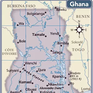
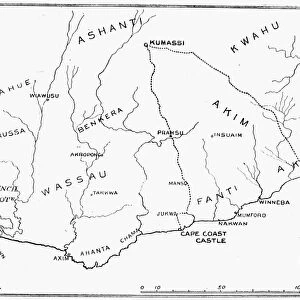
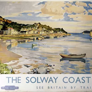
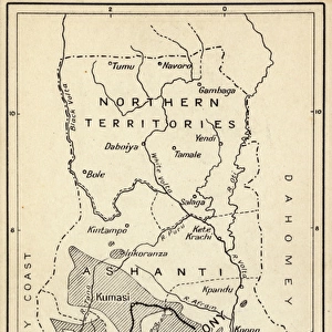
Map, Gold Coast Colony, Ghana, West Africa

![]()
Wall Art and Photo Gifts from Mary Evans Picture Library
Map, Gold Coast Colony, Ghana, West Africa
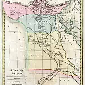
Map, Gold Coast Colony, Ghana, West Africa, with the main cocoa producing areas shaded, a railway line and steamship routes. Also a gold mining area. Date: circa 1920
Mary Evans Picture Library makes available wonderful images created for people to enjoy over the centuries
Media ID 14407566
© Mary Evans / Pharcide
Accra Area Areas Cocoa Colony Ghana Ghanaian Main Maps Mines Mining Producing Routes Shaded Shading Steamship
FEATURES IN THESE COLLECTIONS
> Africa
> Ghana
> Related Images
> Africa
> Related Images
> Animals
> Birds
> Gruiformes
> Rallidae
> African Rail
> Maps and Charts
> Related Images
> Popular Themes
> Railway Posters
EDITORS COMMENTS
This map print, depicting the Gold Coast Colony in West Africa, circa 1920, offers a fascinating glimpse into the region's rich history of cocoa production and mining during the 1920s. The Gold Coast Colony, now modern-day Ghana, was a significant British territory located along the Gulf of Guinea. The map highlights the main cocoa producing areas, shaded in brown, which dominated the economy of the colony. Cocoa was a major cash crop, and its cultivation and export played a crucial role in the region's economic development. The map also reveals the extensive railway line, represented by the intricate network of red lines, which served as the primary means of transportation for the export of raw materials, including cocoa beans and gold, from the interior regions to the coast. The steamship routes, indicated by the blue lines, further facilitated the movement of goods and people between the colony and other parts of the world. The gold mining area, represented by the yellow shading, was another essential component of the Gold Coast Colony's economy. Gold was a significant source of wealth and attracted numerous investors and migrant laborers from various parts of Africa and beyond. The map provides a visual representation of the complex interplay between the colonial administration, resource extraction, and the transportation infrastructure that shaped the economic landscape of the Gold Coast Colony during the 1920s. This map print, with its intricate details and historical significance, offers an engaging perspective on the rich cultural and economic history of Ghana and the Gold Coast Colony during the 1920s. It is an invaluable resource for scholars, historians, and anyone interested in the history of Africa and its colonial past.
MADE IN THE USA
Safe Shipping with 30 Day Money Back Guarantee
FREE PERSONALISATION*
We are proud to offer a range of customisation features including Personalised Captions, Color Filters and Picture Zoom Tools
SECURE PAYMENTS
We happily accept a wide range of payment options so you can pay for the things you need in the way that is most convenient for you
* Options may vary by product and licensing agreement. Zoomed Pictures can be adjusted in the Cart.