Home > Europe > France > Canton > Morbihan
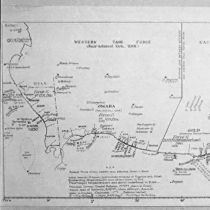
Le Morbihan (56), Brittany - France and its Colonies. Atlas illustrates one hundred and five maps from the maps of the depot of war, bridges and footwear and the Navy by M. VUILLEMIN. 1876
, Brittany - France and its Colonies. Atlas illustrates one hundred and five maps from the maps of the depot of war, bridges and footwear and the Navy by M. VUILLEMIN. 1876")
![]()
Wall Art and Photo Gifts from Fine Art Finder
Le Morbihan (56), Brittany - France and its Colonies. Atlas illustrates one hundred and five maps from the maps of the depot of war, bridges and footwear and the Navy by M. VUILLEMIN. 1876
XEE4144496 Le Morbihan (56), Brittany - France and its Colonies. Atlas illustrates one hundred and five maps from the maps of the depot of war, bridges and footwear and the Navy by M. VUILLEMIN. 1876. by Vuillemin, Alexandre (1812-1886); Private Collection; (add.info.: Le Morbihan (56), Brittany - France and its Colonies. Atlas illustrates one hundred and five maps from the maps of the depot of war, bridges and footwear and the Navy by M. VUILLEMIN. 1876.); Stefano Bianchetti
Media ID 25216680
© Stefano Bianchetti / Bridgeman Images
Alexandre Vuillemin Atlas Book Breton City Map City Plan General Map Morbihan 56 Street Plan Vuillemin Alexandre 1812 1886 Geographical Map
FEATURES IN THESE COLLECTIONS
> Arts
> Portraits
> Pop art gallery
> Street art portraits
> Europe
> France
> Canton
> Morbihan
> Fine Art Finder
> Artists
> Alexandre Vuillemin
> Maps and Charts
> Early Maps
> Maps and Charts
> Related Images
> Services
> Royal Navy
EDITORS COMMENTS
This print showcases a stunning atlas titled "Le Morbihan (56), Brittany - France and its Colonies" created by Alexandre Vuillemin in 1876. The atlas features an impressive collection of one hundred and five maps, sourced from the depot of war, bridges and footwear, as well as the Navy. The image captures the essence of this historical masterpiece, with its intricate engravings and vibrant colors. Each map provides a detailed geographical representation of various regions within Brittany, France, including Le Morbihan (56) and its colonies. Vuillemin's artistic talent shines through in this work of art, demonstrating his expertise as both an artist and cartographer. His meticulous attention to detail is evident in every line and curve on these maps. As we delve into each page of this remarkable atlas, we are transported back to the 19th century – a time when cartography was not only functional but also considered an art form. This print serves as a testament to Vuillemin's contribution to French culture during that era. Whether you are a history enthusiast or simply appreciate fine art, this print offers a glimpse into the rich heritage of Brittany while showcasing the exceptional craftsmanship behind Vuillemin's maps. It is truly a treasure for any collector or admirer of French geography and artwork alike.
MADE IN THE USA
Safe Shipping with 30 Day Money Back Guarantee
FREE PERSONALISATION*
We are proud to offer a range of customisation features including Personalised Captions, Color Filters and Picture Zoom Tools
SECURE PAYMENTS
We happily accept a wide range of payment options so you can pay for the things you need in the way that is most convenient for you
* Options may vary by product and licensing agreement. Zoomed Pictures can be adjusted in the Cart.