Home > Animals > Mammals > Macropodidae > Parma
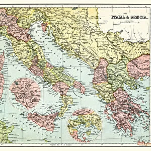
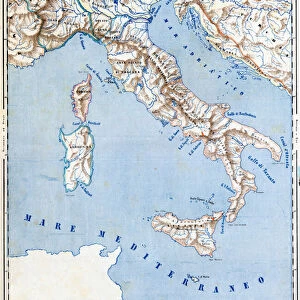
Cartography Hydrographic and Orographic Map of Italy, 1853 (colour litho)
")
![]()
Wall Art and Photo Gifts from Fine Art Finder
Cartography Hydrographic and Orographic Map of Italy, 1853 (colour litho)
6203313 Cartography Hydrographic and Orographic Map of Italy, 1853 (colour litho) by Italian School, (19th century); (add.info.: CARTOGRAPHY " Hydrographic and orographic map of Italy. That is an indication of its seas rivers, lakes and mountains." Detail of the physical map of pre-unitary Italy with the borders of the mid-nineteenth century (see full at FSNGilardi_72507.jpg). Table XII from " The Geography at a glance", Lithography Corbetta, Milan, 1853.); Fototeca Gilardi
Media ID 24691578
© Fototeca Gilardi / Bridgeman Images
Canton Ticino Grand Duchy Of Tuscany Hydrography Island Of Malta Kingdom Of Naples Milan Mounts Reliefs Risorgimento Sardinia Volcano Duchy Of Modena Duchy Of Parma Orography Republic Of San Marino
FEATURES IN THESE COLLECTIONS
> Animals
> Mammals
> Macropodidae
> Parma
> Arts
> Artists
> I
> Italian School Italian School
> Arts
> Artists
> R
> Roman Roman
> Europe
> Italy
> Campania
> Naples
> Europe
> Italy
> Emilia-Romagna
> Modena
> Europe
> Italy
> Lakes
> Related Images
> Europe
> Italy
> Lazio
> Marino
> Europe
> Italy
> Lombardy
> Milan
> Europe
> Italy
> Lombardy
> Related Images
> Fine Art Finder
> Artists
> Augustus Edward Mulready
> Fine Art Finder
> Artists
> Italian School
EDITORS COMMENTS
This vibrant and detailed print showcases the "Cartography Hydrographic and Orographic Map of Italy, 1853". Created by an Italian School in the 19th century, this colour lithograph provides a fascinating glimpse into the geographical features of pre-unitary Italy. The map highlights Italy's seas, rivers, lakes, mountains, and reliefs with meticulous precision. It offers a comprehensive overview of the diverse topography that characterizes this beautiful country. From the Tyrolean Italian region to Sardinia, from Lombardy Veneto Kingdom to Sicily and Naples, every corner is meticulously depicted. Not only does this map serve as a valuable historical document but it also sheds light on the political landscape during that time. The borders of mid-nineteenth-century states such as Roman State, Pontifical State, Republic of San Marino are clearly demarcated. This visual representation allows us to understand how these territories were divided before they unified into modern-day Italy. The colours used in this lithograph bring life to each element on the map - from deep blues for water bodies to vibrant greens for lush landscapes. The engraving techniques employed by Bridgeman Images capture even the smallest details with remarkable clarity. Whether you are a geography enthusiast or simply appreciate fine art prints that offer both aesthetic appeal and historical significance, this Cartography Hydrographic and Orographic Map of Italy is sure to captivate your imagination.
MADE IN THE USA
Safe Shipping with 30 Day Money Back Guarantee
FREE PERSONALISATION*
We are proud to offer a range of customisation features including Personalised Captions, Color Filters and Picture Zoom Tools
SECURE PAYMENTS
We happily accept a wide range of payment options so you can pay for the things you need in the way that is most convenient for you
* Options may vary by product and licensing agreement. Zoomed Pictures can be adjusted in the Cart.