Home > Animals > Mammals > Daubentoniidae > Aye-aye
Ayer MS 1801 Map 1: Map of lands in the Tultepec and Jaltocan regions adjacent to

![]()
Wall Art and Photo Gifts from Fine Art Finder
Ayer MS 1801 Map 1: Map of lands in the Tultepec and Jaltocan regions adjacent to
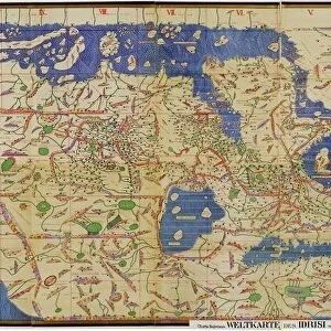
NBY259416 Ayer MS 1801 Map 1: Map of lands in the Tultepec and Jaltocan regions adjacent to the Hacienda de Santa Ines, Mexico, published 1569 (colour litho) by Spanish School, (16th century); Newberry Library, Chicago, Illinois, USA; (add.info.: shows lands between Lake Zumpango and Lake Jaltocan south of the Santa Ines Hacienda (roughly 20 miles north of Mexico City); combines Indian and European symbols to identify five churches, two roads, two sheep corrals, numerous Indian houses, fields, and various boundary lines; ); eNewberry Library; Spanish, out of copyright
Media ID 22362472
© Newberry Library / Bridgeman Images
Boundaries Divisions Fields Territory
FEATURES IN THESE COLLECTIONS
> Animals
> Mammals
> Bovidae
> Sheep
> Animals
> Mammals
> Daubentoniidae
> Aye-aye
> Arts
> Artists
> I
> Indian School Indian School
> Arts
> Artists
> M
> Mexican School Mexican School
> Arts
> Artists
> S
> Spanish School
> Europe
> Spain
> Related Images
> Fine Art Finder
> Artists
> Henri de Toulouse-Lautrec
> Fine Art Finder
> Artists
> Spanish School (after)
> Fine Art Finder
> Maps (celestial & Terrestrial)
EDITORS COMMENTS
This print showcases the Ayer MS 1801 Map 1, a remarkable depiction of lands in the Tultepec and Jaltocan regions adjacent to the Hacienda de Santa Ines in Mexico. Published in 1569, this map is a true testament to the merging of Indian and European cultures during the 16th century. The vibrant colors of this lithograph bring to life the intricate details found within this historical document. It reveals an expansive landscape between Lake Zumpango and Lake Jaltocan, just south of Mexico City. The map ingeniously combines symbols representing five churches, two roads, two sheep corrals, numerous Indian houses, fields, and various boundary lines. As you delve into its depths, you can't help but marvel at how it seamlessly blends both indigenous and colonial influences. This unique fusion offers a glimpse into the complex history of this region. Preserved by the Newberry Library in Chicago, Illinois, USA; this invaluable piece serves as a visual gateway to understanding territorial divisions and boundaries from centuries ago. Its significance lies not only in its cartographic accuracy but also as a testament to cultural exchange during that era. Whether you're an avid historian or simply appreciate fine art prints like these from Bridgeman Images' collection on Fine Art Finder; let yourself be transported back in time through this mesmerizing portrayal of Mexican landscapes rich with history and heritage.
MADE IN THE USA
Safe Shipping with 30 Day Money Back Guarantee
FREE PERSONALISATION*
We are proud to offer a range of customisation features including Personalised Captions, Color Filters and Picture Zoom Tools
SECURE PAYMENTS
We happily accept a wide range of payment options so you can pay for the things you need in the way that is most convenient for you
* Options may vary by product and licensing agreement. Zoomed Pictures can be adjusted in the Cart.