Home > North America > United States of America > New York > New York > Maps
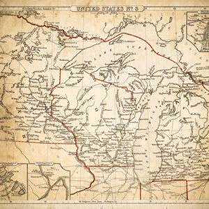
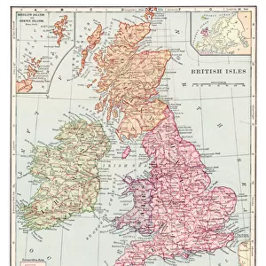
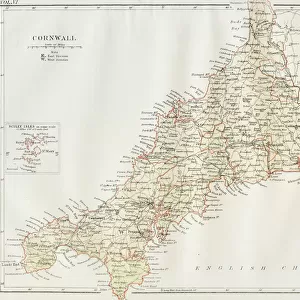
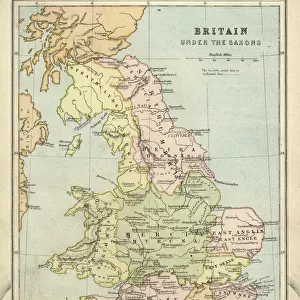
British Isles map of 1869

![]()
Wall Art and Photo Gifts from Fine Art Storehouse
British Isles map of 1869
Cornells Grammar School Geography By S.S. Cornell - New York 1869
Unleash your creativity and transform your space into a visual masterpiece!
THEPALMER
Media ID 18106811
© 2014 Roberto Adrian Photography
FEATURES IN THESE COLLECTIONS
> Fine Art Storehouse
> Map
> Historical Maps
> Maps and Charts
> Related Images
> North America
> United States of America
> New York
> New York
> Maps
> North America
> United States of America
> New York
> Related Images
EDITORS COMMENTS
In this photo print, we are transported back in time to the year 1869, as we explore a meticulously detailed map of the British Isles. Created by S. S. Cornell for his renowned "Cornells Grammar School Geography" publication, this historical artifact offers us a glimpse into the past and serves as a testament to the enduring beauty of cartography. The intricate lines and delicate shading on this map showcase the craftsmanship that went into its creation. Every contour of land is carefully depicted, from the rugged coastlines to the rolling hills and majestic mountain ranges that define these enchanting islands. The names of cities, towns, and villages are elegantly inscribed across their respective locations, inviting our imagination to wander through bustling streets and picturesque landscapes frozen in time. As we admire this vintage piece brought to life by THEPALMER's expert touch at Fine Art Storehouse, it becomes apparent how much has changed over more than a century since its conception. Yet amidst all those changes lie echoes of history waiting to be discovered - stories of triumphs and struggles that have shaped these lands. Whether you're an avid historian or simply appreciate artistry with depth and meaning, this British Isles map from 1869 will undoubtedly captivate your senses while igniting curiosity about generations gone by. It serves as both a reminder of our shared heritage and an invitation to embark on new journeys through time without ever leaving your doorstep.
MADE IN THE USA
Safe Shipping with 30 Day Money Back Guarantee
FREE PERSONALISATION*
We are proud to offer a range of customisation features including Personalised Captions, Color Filters and Picture Zoom Tools
SECURE PAYMENTS
We happily accept a wide range of payment options so you can pay for the things you need in the way that is most convenient for you
* Options may vary by product and licensing agreement. Zoomed Pictures can be adjusted in the Cart.