Home > North America > United States of America > New York > New York > Maps
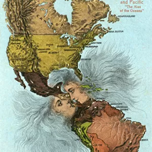
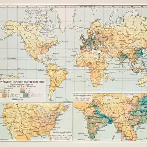
Map of the world in Hemispheres 1899

![]()
Wall Art and Photo Gifts from Fine Art Storehouse
Map of the world in Hemispheres 1899
Maurys Geographical Series Manual of Geography - New York 1899
Unleash your creativity and transform your space into a visual masterpiece!
THEPALMER
Media ID 21177733
© A 2014 Roberto Adrian Photography
FEATURES IN THESE COLLECTIONS
> Fine Art Storehouse
> Map
> Historical Maps
> Maps and Charts
> Early Maps
> Maps and Charts
> World
> North America
> United States of America
> New York
> New York
> Maps
EDITORS COMMENTS
In this print titled "Map of the world in Hemispheres 1899" we are transported back to a time when exploration and discovery were at their peak. The image showcases an exquisite map from Maurys Geographical Series Manual of Geography, published in New York in 1899. The intricate details and vibrant colors of this vintage map immediately draw us into its fascinating narrative. Divided into hemispheres, it offers a comprehensive view of our planet as it was perceived over a century ago. Each continent is meticulously depicted, with mountain ranges, rivers, and coastlines intricately outlined. As we gaze upon this historical artifact, we can't help but marvel at the sheer magnitude of human curiosity that drove explorers to venture into uncharted territories during that era. It serves as a reminder of how far humanity has come in understanding our world's geography since then. "The Map of the World in Hemispheres 1899" by THEPALMER captures not only the beauty but also the significance of cartography as an art form. This print is more than just a decorative piece; it represents a tangible link between past and present—a testament to mankind's insatiable thirst for knowledge about our planet. Whether displayed on your wall or carefully preserved within your collection, this print invites you to embark on a visual journey through time—an opportunity to reflect on our ever-evolving understanding of Earth's vast landscapes and diverse cultures.
MADE IN THE USA
Safe Shipping with 30 Day Money Back Guarantee
FREE PERSONALISATION*
We are proud to offer a range of customisation features including Personalised Captions, Color Filters and Picture Zoom Tools
SECURE PAYMENTS
We happily accept a wide range of payment options so you can pay for the things you need in the way that is most convenient for you
* Options may vary by product and licensing agreement. Zoomed Pictures can be adjusted in the Cart.