Home > Arts > Street art graffiti > Digital art > Vector illustrations
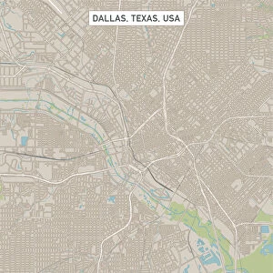
Amarillo Texas US City Street Map

![]()
Wall Art and Photo Gifts from Fine Art Storehouse
Amarillo Texas US City Street Map
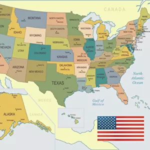
Vector Illustration of a City Street Map of Amarillo, Texas, USA. Scale 1:60, 000.
All source data is in the public domain.
U.S. Geological Survey, US Topo
Used Layers:
USGS The National Map: National Hydrography Dataset (NHD)
USGS The National Map: National Transportation Dataset (NTD)
Unleash your creativity and transform your space into a visual masterpiece!
Frank Ramspott
Media ID 15192950
© Frank Ramspott, all rights reserved
Aerial View City Map Computer Graphic Directly Above Downtown District Gray Road Map Texas Text Amarillo Digitally Generated Image Green Color White Color
FEATURES IN THESE COLLECTIONS
> Aerial Photography
> Related Images
> Animals
> Insects
> Hemiptera
> Green Scale
> Arts
> Contemporary art
> Digital artwork
> Street art
> Arts
> Landscape paintings
> Waterfall and river artworks
> River artworks
> Arts
> Portraits
> Pop art gallery
> Street art portraits
> Arts
> Street art graffiti
> Digital art
> Digital paintings
> Arts
> Street art graffiti
> Digital art
> Vector illustrations
> Fine Art Storehouse
> Map
> Street Maps
> Fine Art Storehouse
> Map
> USA Maps
> Maps and Charts
> Geological Map
> Maps and Charts
> Related Images
> North America
> United States of America
> Lakes
> Related Images
EDITORS COMMENTS
This print showcases a detailed and vibrant city street map of Amarillo, Texas, USA. With a scale of 1:60,000, every intricate detail is brought to life in this vector illustration. The image encompasses the downtown district, highlighting the city's bustling streets and its unique charm. The map incorporates various elements that contribute to its accuracy and reliability. Sourced from USGS The National Map, the National Hydrography Dataset (NHD) ensures precise representation of lakes and rivers within Amarillo. Additionally, the National Transportation Dataset (NTD) accurately depicts roads and transportation routes throughout the city. Designed with meticulous care by Frank Ramspott using computer graphics technology, this digitally generated image captures an aerial view directly above Amarillo. Its color palette includes shades of gray, blue, white, and green which beautifully complement each other. As a result of utilizing public domain source data from U. S. Geological Survey's US Topo project - specifically The National Map - this artwork guarantees authenticity while maintaining legal compliance. Perfect for enthusiasts of cartography or those with a deep appreciation for urban landscapes, this print offers an intriguing perspective on Amarillo's physical geography. With no people present in the image itself but accompanied by informative text detailing key features represented on the map; it serves as both an aesthetically pleasing piece and a valuable reference tool.
MADE IN THE USA
Safe Shipping with 30 Day Money Back Guarantee
FREE PERSONALISATION*
We are proud to offer a range of customisation features including Personalised Captions, Color Filters and Picture Zoom Tools
SECURE PAYMENTS
We happily accept a wide range of payment options so you can pay for the things you need in the way that is most convenient for you
* Options may vary by product and licensing agreement. Zoomed Pictures can be adjusted in the Cart.