Home > Arts > Street art graffiti > Digital art > Vector illustrations
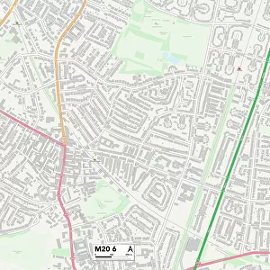
Long Beach California US City Street Map

![]()
Wall Art and Photo Gifts from Fine Art Storehouse
Long Beach California US City Street Map
Vector Illustration of a City Street Map of Long Beach, California, USA. Scale 1:60, 000.
All source data is in the public domain.
U.S. Geological Survey, US Topo
Used Layers:
USGS The National Map: National Hydrography Dataset (NHD)
USGS The National Map: National Transportation Dataset (NTD)
Unleash your creativity and transform your space into a visual masterpiece!
Frank Ramspott
Media ID 15055171
© Frank Ramspott, all rights reserved
Aerial View Blue Color California Computer Graphic Directly Above Downtown Gray Color Long Beach Los Angeles Pacific Ocean Road Map Street Map Text Digitally Generated Image Green Color Los Angeles River White Color
FEATURES IN THESE COLLECTIONS
> Aerial Photography
> Related Images
> Animals
> Insects
> Hemiptera
> Green Scale
> Animals
> Mammals
> Cricetidae
> California Mouse
> Arts
> Artists
> O
> Oceanic Oceanic
> Arts
> Contemporary art
> Digital artwork
> Street art
> Arts
> Landscape paintings
> Waterfall and river artworks
> River artworks
> Arts
> Portraits
> Pop art gallery
> Street art portraits
> Arts
> Street art graffiti
> Digital art
> Digital paintings
> Arts
> Street art graffiti
> Digital art
> Vector illustrations
> Fine Art Storehouse
> Map
> Street Maps
> Fine Art Storehouse
> Map
> USA Maps
> Maps and Charts
> Geological Map
EDITORS COMMENTS
This print showcases a detailed and intricate city street map of Long Beach, California, USA. With a scale of 1:60,000, this vector illustration provides an accurate representation of the city's layout. The image encompasses various elements that make up the vibrant fabric of Long Beach. From its bustling downtown area to the serene Pacific Ocean coastline, every aspect is beautifully depicted in this digitally generated artwork. The meandering Los Angeles River can be seen flowing through the cityscape, adding to its charm and character. Surrounding areas such as Los Angeles and nearby lakes are also included in this comprehensive map. The design seamlessly combines cartography with modern aesthetics, resulting in a visually striking composition. Shades of gray, green, blue, and white create a harmonious color palette that enhances the overall appeal. This aerial view from directly above allows viewers to appreciate the physical geography and architectural diversity present within Long Beach. Notably absent from this image are people themselves; instead, attention is solely focused on capturing the essence of the city through its streets and buildings. Frank Ramspott skillfully crafted this piece using publicly available data sources like USGS The National Map: National Hydrography Dataset (NHD) and USGS The National Map: National Transportation Dataset (NTD). This stunning print serves as both an informative tool for navigation enthusiasts and an aesthetically pleasing work of art for admirers of urban landscapes.
MADE IN THE USA
Safe Shipping with 30 Day Money Back Guarantee
FREE PERSONALISATION*
We are proud to offer a range of customisation features including Personalised Captions, Color Filters and Picture Zoom Tools
SECURE PAYMENTS
We happily accept a wide range of payment options so you can pay for the things you need in the way that is most convenient for you
* Options may vary by product and licensing agreement. Zoomed Pictures can be adjusted in the Cart.