Home > Arts > Modern art pieces
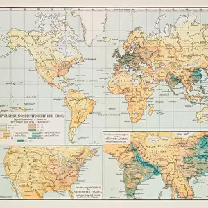
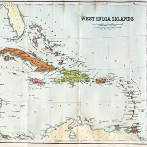
Cuba lesser antilles map 1897

![]()
Wall Art and Photo Gifts from Fine Art Storehouse
Cuba lesser antilles map 1897
The World-Wide Atlas of Modern Geography, Political and Physical W. & A.K. Johnston - London 1897
Unleash your creativity and transform your space into a visual masterpiece!
THEPALMER
Media ID 14757114
© Roberto A Sanchez
Antilles Atlas Bahamas Barbados Bermuda Caribbean Sea Country Geographic Area Cuba Earth Florida Usa Haiti Island Lesser Antilles Paper Puerto Rico Textured Effect Trinidad And Tobago West Indies World Map Retro Styled
FEATURES IN THESE COLLECTIONS
> Arts
> Modern art pieces
> Textures and patterns in modern
> Modern paintings
> Arts
> Modern art pieces
> Textures and patterns in modern
> Europe
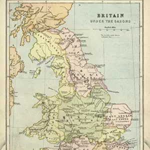
> United Kingdom
> England
> London
> Politics
> Related Images
> Fine Art Storehouse
> Map
> Historical Maps
> Fine Art Storehouse
> Map
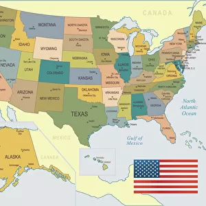
> USA Maps
> Maps and Charts
> Related Images
> Maps and Charts
> World
> North America
> The Bahamas
> Maps
> North America
> The Bahamas
> Related Images
> North America
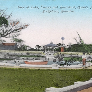
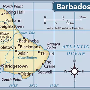
> Barbados
> Maps
> North America
> Barbados
> Related Images
EDITORS COMMENTS
This print takes us back in time to the year 1897, showcasing a meticulously detailed map of Cuba and the Lesser Antilles. The vintage charm of this piece is evident through its retro styling and antique appeal. It is an engraved image from "The World-Wide Atlas of Modern Geography, Political and Physical" by W. & A. K. Johnston, published in London. The intricate cartography on display here offers a glimpse into the past, revealing the physical geography of this Caribbean region with remarkable precision. From Trinidad and Tobago to Haiti, Puerto Rico to Barbados, each island is intricately depicted in this textured effect engraving. As we explore this historical artifact further, we are transported across the vast expanse of the Caribbean Sea that surrounds these islands. The map also includes neighboring regions such as Bermuda, Florida USA, Bahamas - all forming part of what was known as the West Indies during that era. With its earthy tones and aged paper texture, this print evokes a sense of nostalgia for a time long gone by. It serves as a reminder not only of our ever-changing world but also highlights the enduring beauty found within maps themselves. "The Cuba Lesser Antilles Map 1897" by THEPALMER captures both artistry and scientific accuracy in one frame – making it an ideal addition for any history enthusiast or lover of vintage aesthetics seeking to adorn their space with timeless elegance.
MADE IN THE USA
Safe Shipping with 30 Day Money Back Guarantee
FREE PERSONALISATION*
We are proud to offer a range of customisation features including Personalised Captions, Color Filters and Picture Zoom Tools
SECURE PAYMENTS
We happily accept a wide range of payment options so you can pay for the things you need in the way that is most convenient for you
* Options may vary by product and licensing agreement. Zoomed Pictures can be adjusted in the Cart.