Home > Africa > Guinea > Maps
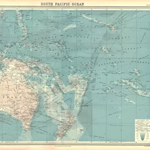
Map of Australasia (1882 engraving)
")
![]()
Wall Art and Photo Gifts from Fine Art Storehouse
Map of Australasia (1882 engraving)
Old map of Australasia from Royal Geographical Readers no. 5 of Asia, Africa, America and Oceania, publ. T Nelson & Sons, London in 1883
Unleash your creativity and transform your space into a visual masterpiece!
whitemay
Media ID 15488347
© Linda Steward
Australasia Australia British Empire Colonial Style Ephemera Exploration Image Created 1880 1889 Indonesia Island Of Borneo Java Monochrome New South Wales New Zealand Northern Territory Pacific Ocean Papua New Guinea Past Polynesia Queensland Sepia Toned Sketch Social History South Australia Tasmania Traditional Culture Western Australia Antarctic Sea Celebes Sea Coral Sea Image Created 19th Century North Australia Obsolete Solomon Islands Victoria State
FEATURES IN THESE COLLECTIONS
> Africa
> Guinea
> Related Images
> Africa
> Related Images
> Africa
> South Africa
> Maps
> Africa
> South Africa
> Related Images
> Animals
> Mammals
> Muridae
> Western Mouse
> Arts
> Artists
> O
> Oceanic Oceanic
> Arts
> Minimalist artwork
> Monochrome artwork
> Fine art
> Arts
> Minimalist artwork
> Monochrome artwork
> Monochrome paintings
> Fine Art Storehouse
> Map
> Historical Maps
> Fine Art Storehouse
> Photo Libraries
> The Illustrated London News (ILN)
EDITORS COMMENTS
This print takes us back in time to the late 19th century, showcasing an exquisite engraving of a Map of Australasia. With its monochrome and sepia-toned palette, it exudes a sense of nostalgia and antiquity. The intricate details captured in this old map from Royal Geographical Readers no. 5 by T Nelson & Sons transport us to an era when cartography was both a science and an art form. The image reveals the vastness of the British Empire during that period, with Australia at its heart. From the island of Borneo to New Zealand, South Australia to Papua New Guinea, this map encompasses not only physical geography but also hints at the social history and exploration that shaped these lands. As we explore this piece further, we are reminded of traditional cultures intertwined with colonial influences across Australasia. The sketch-like quality adds charm while highlighting how far our understanding of these regions has evolved since then. Whether you are a history enthusiast or simply appreciate fine art, this stunning print is sure to captivate your imagination as you embark on a visual journey through time and space. It serves as a testament to the rich heritage and diverse landscapes that define Australasia's past while inviting contemplation about how much has changed since those early days of discovery.
MADE IN THE USA
Safe Shipping with 30 Day Money Back Guarantee
FREE PERSONALISATION*
We are proud to offer a range of customisation features including Personalised Captions, Color Filters and Picture Zoom Tools
SECURE PAYMENTS
We happily accept a wide range of payment options so you can pay for the things you need in the way that is most convenient for you
* Options may vary by product and licensing agreement. Zoomed Pictures can be adjusted in the Cart.