Home > Arts > Artists > W > Frederick de Wit
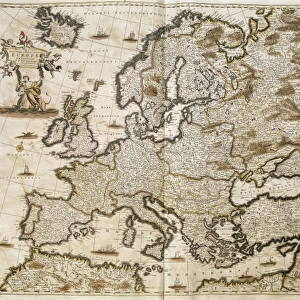
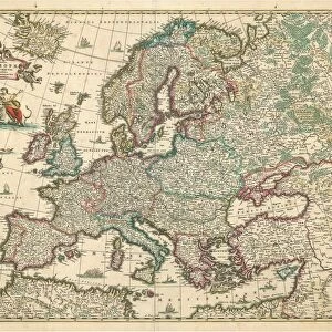
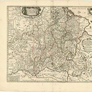
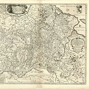
Map Nova et accurate divisa regna et regiones praecipuas Europae descriptio

![]()
Wall Art and Photo Gifts from Liszt Collection
Map Nova et accurate divisa regna et regiones praecipuas Europae descriptio
Map, Nova et accurate divisa in regna et regiones praecipuas Europae descriptio per F. de Witt Amstelodami, Frederick de Wit (1630-1706), Copperplate print
Liszt Collection of nineteenth-century engravings and images to browse and enjoy
Media ID 19584853
© Artokoloro
1630 1706 Copperplate Print Frederick De Wit
FEATURES IN THESE COLLECTIONS
> Arts
> Artists
> W
> Frederick de Wit
> Maps and Charts
> Related Images
EDITORS COMMENTS
This print showcases the remarkable "Map Nova et accurate divisa regna et regiones praecipuas Europae descriptio" by Frederick de Wit, a renowned cartographer from the 17th century. With its intricate details and exquisite craftsmanship, this copperplate print is a true testament to De Wit's skill and artistry. The map itself provides an extraordinary depiction of Europe, meticulously divided into kingdoms and principal regions. Every line, curve, and symbol on this masterpiece tells a story of exploration and discovery during a time when maps were not just navigational tools but works of art. Frederick de Wit's contribution to cartography cannot be overstated. His maps were highly sought after for their accuracy and aesthetic appeal. This particular print captures the essence of his genius as it transports us back in time to an era where geography was still being explored. As we gaze upon this stunning piece, we can't help but marvel at the level of detail that went into creating such an intricate map. The delicate lines tracing coastlines, rivers meandering through vast landscapes, and cities marked with tiny dots all come together to form a visual feast for our eyes. Whether you are a history enthusiast or simply appreciate fine art, this print allows you to own a piece of European cartographic history. It serves as both a reminder of how far we have come in understanding our world and an homage to the brilliance of Frederick de Wit's work.
MADE IN THE USA
Safe Shipping with 30 Day Money Back Guarantee
FREE PERSONALISATION*
We are proud to offer a range of customisation features including Personalised Captions, Color Filters and Picture Zoom Tools
SECURE PAYMENTS
We happily accept a wide range of payment options so you can pay for the things you need in the way that is most convenient for you
* Options may vary by product and licensing agreement. Zoomed Pictures can be adjusted in the Cart.