Home > Animals > Birds > Waterfowl > Ducks > Mallard
Horsham BN5 9 Map

![]()
Wall Art and Photo Gifts from Map Marketing
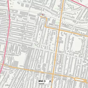
Horsham BN5 9 Map
Postcode Sector Map of Horsham BN5 9
Media ID 19967478
Barrow Hill Benson Road Beverley Road Brighton Road Broomfield Road Cedar Way Chantry Close Chestnut Way Church Lane Church Street Coopers Way Croft Lane Deer Park Farm Close Fletcher Way Golden Square Greenways High Street Hillside Lane Horn Lane Horsham Hudson Way Jubilee Close Kent Street Kingsfield Knowles Close London Road Lower Station Road Mallard Way Manor Close Manor Way Meadow Drive Mill Drive Mill End New Hall Lane Newbarn Lane Northcroft Oakhurst Orchard Close Park Road Parsonage Road Sands Lane Sandy Lane Shoreham Road Silver Birches South View Terrace Station Road Stonepit Lane The Beeches The Laurels Weavers Lane West End West End Lane Wheatsheaf Road Windmill Lane Wood Lane Woodmancote Beech Wood Blackstone Downsview Fulking Henfield
FEATURES IN THESE COLLECTIONS
> Animals
> Birds
> Waterfowl
> Ducks
> Mallard
> Animals
> Fishes
> P
> Perch
> Animals
> Insects
> Spiders
> Silver Garden
> Animals
> Mammals
> Cricetidae
> Golden Mouse
> Animals
> Mammals
> Muridae
> Peters Mouse
> Arts
> Artists
> B
> Banfield Banfield
> Europe
> United Kingdom
> England
> Kent
> Brook Street
> Europe
> United Kingdom
> England
> Kent
> Brook
> Europe
> United Kingdom
> England
> Kent
> Broomfield
> Europe
> United Kingdom
> England
> Kent
> Church Street
> Map Marketing
> Postcode Sector Maps
> BN - Brighton
MADE IN THE USA
Safe Shipping with 30 Day Money Back Guarantee
FREE PERSONALISATION*
We are proud to offer a range of customisation features including Personalised Captions, Color Filters and Picture Zoom Tools
SECURE PAYMENTS
We happily accept a wide range of payment options so you can pay for the things you need in the way that is most convenient for you
* Options may vary by product and licensing agreement. Zoomed Pictures can be adjusted in the Cart.