Home > Animals > Fishes > E > Elver
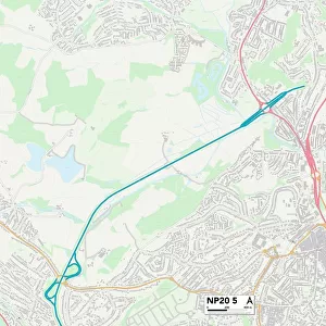
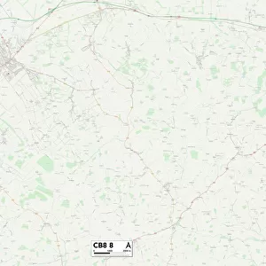
West Norfolk PE34 4 Map

![]()
Wall Art and Photo Gifts from Map Marketing
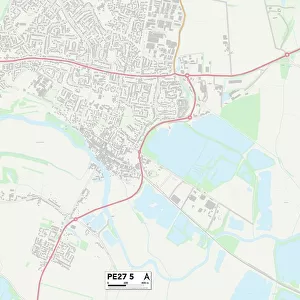
West Norfolk PE34 4 Map
Postcode Sector Map of West Norfolk PE34 4
Media ID 19976824
Alma Avenue Anchor Road Ashfield Court Bailey Lane Benedict Close Beverley Way Chapel Road Church Bank Church Field Church Lane Church Road Ferry Road Franklin Close Grange Road Greens Lane Hall Road Howard Close Hunters Close Linden Road Long Road Low Lane Low Road Lynn Road Magdalen Road Main Road Manor Road Market Lane Marsh Road Middle Road Mill Lane Moat Road New Road Nursery Close Oldfield Drive Orchard Close Oxford Place Pingle Lane Popes Lane Rectory Drive Rookery Close Rookery Road School Road South Green Spring Grove St Annes Crescent St Johns Road Station Road Station Road North Sutton Road The Hollies The Saltings Tower Road Vicarage Close Victoria Road Wash Lane Wesley Avenue Wesley Close Wesley Road West Norfolk Westfields Willow Drive Workhouse Lane Linford Victory Lane
FEATURES IN THESE COLLECTIONS
> Animals
> Fishes
> E
> Elver
> Animals
> Fishes
> P
> Poacher
> Architecture
> Towers
> Churches
> Architecture
> Towers
> Victoria Tower
> Arts
> Artists
> F
> John Field
> Arts
> Artists
> H
> John Hillers
> Arts
> Artists
> H
> John Hills
> Arts
> Artists
> J
> John Jarvis
> Arts
> Artists
> J
> John Wesley Jarvis
> Arts
> Artists
> K
> Nicholas King
> Map Marketing
> Postcode Sector Maps
> PE - Peterborough
MADE IN THE USA
Safe Shipping with 30 Day Money Back Guarantee
FREE PERSONALISATION*
We are proud to offer a range of customisation features including Personalised Captions, Color Filters and Picture Zoom Tools
SECURE PAYMENTS
We happily accept a wide range of payment options so you can pay for the things you need in the way that is most convenient for you
* Options may vary by product and licensing agreement. Zoomed Pictures can be adjusted in the Cart.