Home > Europe > United Kingdom > England > London > Boroughs > Havering
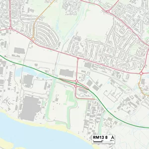
Havering RM13 8 Map

![]()
Wall Art and Photo Gifts from Map Marketing
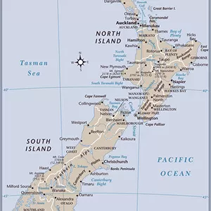
Havering RM13 8 Map
Postcode Sector Map of Havering RM13 8
Media ID 19979646
Auckland Avenue Blackwater Close Blake Close Cherry Tree Lane Christchurch Avenue Collingwood Road Dunedin Road Edmund Road Edwin Close Frederick Road Frog Lane Havering Hood Road Hubert Road Karen Close Manor Way Marsh Way Maytree Close Nelson Road Neptune Close New Road Pear Tree Lane Philip Road Plum Lane Queens Gardens South Street Spencer Road Spinney Close Trafalgar Road Walden Avenue
FEATURES IN THESE COLLECTIONS
> Animals
> Amphibians
> Frogs
> Treefrogs
> Related Images
> Arts
> Artists
> H
> Hubert Hubert
> Europe
> United Kingdom
> England
> London
> Boroughs
> Havering
> Europe
> United Kingdom
> England
> London
> Politics
> Frederick North
> Map Marketing
> Postcode Sector Maps
> RM - Romford
> Maps and Charts
> Related Images
> Oceania
> New Zealand
> Auckland
> Oceania
> New Zealand
> Christchurch
> Oceania
> New Zealand
> Dunedin
> Oceania
> New Zealand
> Maps
> Oceania
> New Zealand
> Related Images
MADE IN THE USA
Safe Shipping with 30 Day Money Back Guarantee
FREE PERSONALISATION*
We are proud to offer a range of customisation features including Personalised Captions, Color Filters and Picture Zoom Tools
SECURE PAYMENTS
We happily accept a wide range of payment options so you can pay for the things you need in the way that is most convenient for you
* Options may vary by product and licensing agreement. Zoomed Pictures can be adjusted in the Cart.