Home > Europe > United Kingdom > England > London > Boroughs > Merton
Rochford SS5 6 Map

![]()
Wall Art and Photo Gifts from Map Marketing
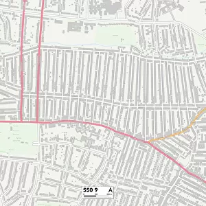
Rochford SS5 6 Map
Postcode Sector Map of Rochford SS5 6
Media ID 19978644
Abbey Close Abbey Road Almond Avenue Ambleside Gardens Ashdene Close Beech Road Broom Road Burlington Gardens Burnham Road Cedar Drive Central Avenue Church Road Coventry Close Cranleigh Gardens Elm Grove Ferry Road First Avenue Grasmere Avenue High Bank Hillcrest Avenue Hilltop Avenue Kendal Close Keswick Avenue Kingsway Long Lane Lower Road Main Road Mayfield Avenue Meadow Road Merton Road Oakleigh Avenue Pinewood Close Queens Avenue Ridge Way Rochford Rydal Close South Avenue St Peters Road The Avenue The Drive The Esplanade The Walk Wallace Close Wellington Avenue West Avenue Windermere Avenue Hullbridge
FEATURES IN THESE COLLECTIONS
> Animals
> Mammals
> Muridae
> Peters Mouse
> Architecture
> Towers
> Churches
> Europe
> United Kingdom
> England
> London
> Boroughs
> Merton
> Map Marketing
> Postcode Sector Maps
> SS - Southend-on-Sea
MADE IN THE USA
Safe Shipping with 30 Day Money Back Guarantee
FREE PERSONALISATION*
We are proud to offer a range of customisation features including Personalised Captions, Color Filters and Picture Zoom Tools
SECURE PAYMENTS
We happily accept a wide range of payment options so you can pay for the things you need in the way that is most convenient for you
* Options may vary by product and licensing agreement. Zoomed Pictures can be adjusted in the Cart.