Home > Europe > United Kingdom > England > London > Boroughs > Hounslow
Hounslow TW4 5 Map

![]()
Wall Art and Photo Gifts from Map Marketing
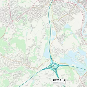
Hounslow TW4 5 Map
Postcode Sector Map of Hounslow TW4 5
Media ID 19980070
Amelia Close Arden Close Avondale Gardens Beaulieu Close Bennett Close Beresford Gardens Beverley Avenue Bramley Way Brompton Close Carisbrooke Close Connaught Avenue Conway Road Corfe Close Curtis Road Drayton Close Edgar Road Farm Road Fir Tree Road Frampton Road Gloucester Road Grafton Close Hanworth Road Hounslow Ivy Lane Marshall Close Meadow Close Millfield Road Nursery Gardens Pickwick Close Raglan Close Simpson Road Staines Road Wyndham Crescent Hounslow Heath
FEATURES IN THESE COLLECTIONS
> Animals
> Mammals
> Muridae
> Heath Mouse
> Europe
> United Kingdom
> England
> London
> Boroughs
> Hounslow
> Europe
> United Kingdom
> Scotland
> Aberdeenshire
> Blackburn
> Europe
> United Kingdom
> Scotland
> West Lothian
> Blackburn
> Map Marketing
> Postcode Sector Maps
> TW - Twickenham
> Maps and Charts
> Related Images
MADE IN THE USA
Safe Shipping with 30 Day Money Back Guarantee
FREE PERSONALISATION*
We are proud to offer a range of customisation features including Personalised Captions, Color Filters and Picture Zoom Tools
SECURE PAYMENTS
We happily accept a wide range of payment options so you can pay for the things you need in the way that is most convenient for you
* Options may vary by product and licensing agreement. Zoomed Pictures can be adjusted in the Cart.