Home > Arts > Artists > R > Roman Roman
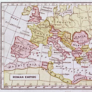
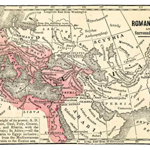
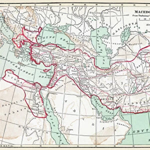
Map of the Dacian Empire and Roman provinces

![]()
Wall Art and Photo Gifts from Mary Evans Picture Library
Map of the Dacian Empire and Roman provinces
Map of the Dacian Empire and Roman provinces. Date: 1801
Mary Evans Picture Library makes available wonderful images created for people to enjoy over the centuries
Media ID 11575343
© Mary Evans / Grenville Collins Postcard Collection
1801 Adriatic Balkan Balkans Chart Dacia Dacian Dalmatia Dalmatian Danube Illyria Illyrians Macedonia Maps Region Serbia Serbian Slavic Yugoslavia Dobrogea Pannonia
FEATURES IN THESE COLLECTIONS
> Arts
> Artists
> R
> Roman Roman
> Arts
> Landscape paintings
> Waterfall and river artworks
> River artworks
> Europe
> Macedonia
> Posters
> Europe
> Macedonia
> Related Images
> Europe
> Related Images
> Europe
> Serbia
> Related Images
EDITORS COMMENTS
1. Title: "Map of the Dacian Empire and Roman Provinces in the Balkan Region, 1801" This map print, produced in the year 1801, offers a fascinating glimpse into the historical geography of the Balkan Peninsula during the classical antiquity period. The map meticulously delineates the territories of the Dacian Empire, a powerful and ancient civilization located in the central and eastern parts of the region, as well as the Roman provinces that succeeded it. The Dacian Empire, inhabited primarily by the Dacians, Getae, and other related tribes, is depicted in rich detail, with its capital city, Sarmizegetusa Regia, clearly marked. The empire's borders extend from the Carpathian Mountains in the north to the Danube River in the south, encompassing present-day Romania, Moldova, and parts of Hungary and Bulgaria. Surrounding the Dacian Empire are the Roman provinces, including Moesia, Pannonia, Dalmatia, Illyria, Thracia, and Macedonia. The Danube River, a vital waterway during this time, is prominently featured, with its tributaries and major cities labeled. The Adriatic Sea, the Illyrian coast, and the Pannonian Plain are also shown, providing context to the geographical layout of the region. This map serves as an essential historical resource, revealing the complex political landscape of the Balkans during the transition from the Dacian Empire to Roman rule. It is an invaluable tool for scholars, students, and history enthusiasts, offering a unique perspective on the rich cultural heritage of the Balkans and its ancient civilizations. Keywords: Dacia, Dacian Empire, Map, Maps, Chart, Key, Balkan Region, Balkans, Yugoslavia, Slavic States, Adriatic Sea, Central Europe, Macedonia, Thracia, Illyria, 1801, Classical Antiquity, Illyrians, Getae, Danubius, River Danube, Moesia, Dobrogea, Serbia, Serbian, Pannonia, Dalmatian, Dalmatia, Pannonii, Pannonians, History, Historical.
MADE IN THE USA
Safe Shipping with 30 Day Money Back Guarantee
FREE PERSONALISATION*
We are proud to offer a range of customisation features including Personalised Captions, Color Filters and Picture Zoom Tools
SECURE PAYMENTS
We happily accept a wide range of payment options so you can pay for the things you need in the way that is most convenient for you
* Options may vary by product and licensing agreement. Zoomed Pictures can be adjusted in the Cart.