Home > Europe > Russia > Maps
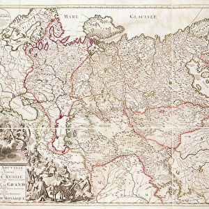
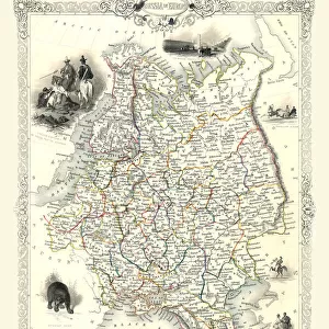
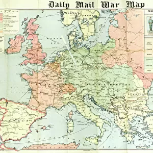
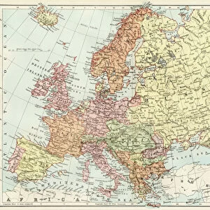
MAP / RUSSIA / SIBERIA C1760

![]()
Wall Art and Photo Gifts from Mary Evans Picture Library
MAP / RUSSIA / SIBERIA C1760
Siberia and adjacent regions : St Petersburg and Moscow are on the far left, Irkutsk centre low right Date: circa 1760
Mary Evans Picture Library makes available wonderful images created for people to enjoy over the centuries
Media ID 20151165
© Bubblepunk
1760 Adjacent Irkutsk Maps Moscow Petersburg Regions Siberia C1760
FEATURES IN THESE COLLECTIONS
> Europe
> Related Images
> Europe
> Russia
> Heritage Sites
> Historic Centre of Saint Petersburg
> Europe
> Russia
> Related Images
> Maps and Charts
> Related Images
> Mary Evans Prints Online
> New Images July 2020
EDITORS COMMENTS
This intriguing map print, titled "Siberia and adjacent regions," dates back to circa 1760 and offers a fascinating glimpse into the geographical knowledge of Russia during that period. The map, part of the extensive collection available at Mary Evans Prints Online, provides an intricate and detailed representation of Siberia and its neighboring territories. The map's primary focus is on the vast expanse of Siberia, stretching from the Ural Mountains in the west to the Pacific Ocean in the east. The map also includes parts of present-day Kazakhstan, Mongolia, and China. Notable cities and landmarks are marked, such as Irkutsk, the administrative center of Eastern Siberia, and Tomsk, an important educational and cultural hub. St Petersburg and Moscow, Russia's two most significant cities at the time, are depicted on the far left of the map. The map's creator meticulously labeled various rivers, mountains, and bodies of water, providing valuable information for explorers, traders, and diplomats. The map's cartographic style reflects the European influence on Russian cartography during the 18th century. The use of latitude and longitude lines, as well as the inclusion of place names in both Latin and Cyrillic scripts, demonstrates the blending of European and Russian cartographic traditions. This map print serves as an essential historical document, offering insights into the geographical knowledge and exploration of Siberia and its neighboring regions during the 18th century. It is a testament to the curiosity and ambition of explorers and cartographers, who sought to chart the unknown and expand the boundaries of human knowledge.
MADE IN THE USA
Safe Shipping with 30 Day Money Back Guarantee
FREE PERSONALISATION*
We are proud to offer a range of customisation features including Personalised Captions, Color Filters and Picture Zoom Tools
SECURE PAYMENTS
We happily accept a wide range of payment options so you can pay for the things you need in the way that is most convenient for you
* Options may vary by product and licensing agreement. Zoomed Pictures can be adjusted in the Cart.