Home > Europe > United Kingdom > England > North Yorkshire > Related Images
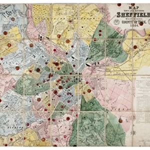
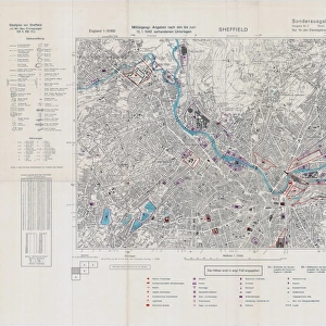
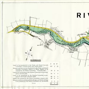
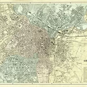
Ordnance Survey map of north east Sheffield copied by the Germans, and marked with bombing targets, c. 1940

![]()
Wall Art and Photo Gifts from Sheffield City Archives
Ordnance Survey map of north east Sheffield copied by the Germans, and marked with bombing targets, c. 1940
Original at Sheffield City Archives MD7731/4 and Sheffield Local Studies Librarys 26 M/5
Sheffield City Archives and Local Studies Library has an unrivalled collection of images of Sheffield, England
Media ID 14046757
© Sheffield City Council
Attercliffe Brightside Carbrook Coal Collieries Darnall Grimesthorpe Industry Maps Park River Don Rivers Second World War Sheffield Steel Tinsley World War Two Yorkshire Air Raids Bombs Colliery Handsworth Hecla Nunnery World War
FEATURES IN THESE COLLECTIONS
> Europe
> United Kingdom
> England
> North Yorkshire
> Related Images
> Europe
> United Kingdom
> England
> Yorkshire
> Attercliffe
> Europe
> United Kingdom
> England
> Yorkshire
> Brightside
> Europe
> United Kingdom
> England
> Yorkshire
> Darnall
> Europe
> United Kingdom
> England
> Yorkshire
> Handsworth
> Europe
> United Kingdom
> England
> Yorkshire
> Related Images
> Europe
> United Kingdom
> England
> Yorkshire
> Sheffield
> Europe
> United Kingdom
> England
> Yorkshire
> Tinsley
> Sheffield City Archives
> Maps and Plans
EDITORS COMMENTS
This print showcases an extraordinary piece of history - an Ordnance Survey map of north east Sheffield, meticulously copied by the Germans during World War II. The map is not only a testament to the strategic importance of Sheffield during this tumultuous period but also reveals the chilling reality of war. Imprinted on this map are ominous markings denoting bombing targets carefully selected by the German forces. It serves as a haunting reminder of the constant threat faced by Sheffield's residents and its vital industrial infrastructure. The areas highlighted include Catcliffe, Attercliffe, Tinsley, Brightside, Park, Grimesthorpe, Carbrook, Hecla, Nunnery, Darnall, Handsworth, Brinsworth and Orgreave - all bearing witness to devastating air raids that ravaged these neighborhoods. The presence of coal mines and steelworks in close proximity further underscores Sheffield's significance as a key hub for industry during wartime. The River Don winds through the map like a lifeline connecting these vital centers of production. Preserved at both Sheffield City Archives (MD7731/4) and Sheffield Local Studies Library (26 M/5), this original document offers invaluable insights into how cities were targeted strategically during World War II. Its historical value cannot be overstated; it provides us with a tangible link to our past and reminds us never to forget the sacrifices made by those who lived through such turbulent times
MADE IN THE USA
Safe Shipping with 30 Day Money Back Guarantee
FREE PERSONALISATION*
We are proud to offer a range of customisation features including Personalised Captions, Color Filters and Picture Zoom Tools
SECURE PAYMENTS
We happily accept a wide range of payment options so you can pay for the things you need in the way that is most convenient for you
* Options may vary by product and licensing agreement. Zoomed Pictures can be adjusted in the Cart.