Home > Europe > United Kingdom > England > West Sussex > East Grinstead
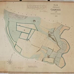
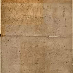
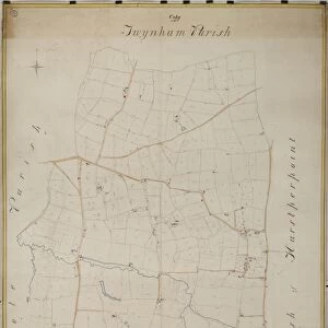
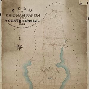
East Grinstead tithe map, 1840

![]()
Wall Art and Photo Gifts from West Sussex County Council
East Grinstead tithe map, 1840
Surveyor unknown. 13.3 in to 1 m. 89 × 83
Tithe Award Map Collection
West Sussex Record Office Ref No: TD/E45
West Sussex County Council Record Office contains a fascinating history of the county of West Sussex, England
Media ID 10716269
© West Sussex County Council - All Rights Reserved
1840s 19th Century Historical Mapping South Of England
FEATURES IN THESE COLLECTIONS
> Europe
> United Kingdom
> England
> East Sussex
> Related Images
> Europe
> United Kingdom
> England
> Ely
> Europe
> United Kingdom
> England
> Maps
> Europe
> United Kingdom
> England
> Sussex
> East Grinstead
> Europe
> United Kingdom
> England
> Sussex
> Related Images
> Europe
> United Kingdom
> England
> Sussex
> West Grinstead
> Europe
> United Kingdom
> England
> West Sussex
> East Grinstead
> Europe
> United Kingdom
> England
> West Sussex
> Related Images
> Maps and Charts
> Early Maps
> Maps and Charts
> Related Images
> West Sussex County Council
> West Sussex Record Office
> Tithe Award Maps, 1808-1859
EDITORS COMMENTS
This print showcases the East Grinstead tithe map from 1840, a remarkable piece of historical mapping that offers a glimpse into the past. The surveyor responsible for this intricate creation remains unknown, adding an air of mystery to its allure. Measuring at an impressive scale of 13.3 inches to 1 meter, this map spans an expansive area measuring approximately 89 by 83 meters. Part of the esteemed Tithe Award Map Collection housed at the West Sussex Record Office, this artifact holds immense value in preserving our understanding of land ownership and usage during the 19th century in southern England. Its meticulous details provide valuable insights into how communities were structured and how land was divided among various stakeholders. It is important to note that this caption does not refer to any specific company or commercial use associated with the photograph or its subject matter. Instead, it focuses solely on highlighting the historical significance and geographic scope encapsulated within this extraordinary piece of cartography. Thanks to West Sussex County Council's commitment to preserving such invaluable records, we are fortunate enough to witness history come alive through these fascinating relics. This particular print serves as a testament to their dedication in safeguarding our heritage for generations to come.
MADE IN THE USA
Safe Shipping with 30 Day Money Back Guarantee
FREE PERSONALISATION*
We are proud to offer a range of customisation features including Personalised Captions, Color Filters and Picture Zoom Tools
SECURE PAYMENTS
We happily accept a wide range of payment options so you can pay for the things you need in the way that is most convenient for you
* Options may vary by product and licensing agreement. Zoomed Pictures can be adjusted in the Cart.