Home > Europe > United Kingdom > England > West Sussex > Horsham
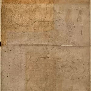
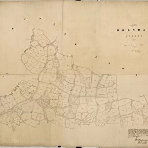
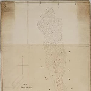
Horsham tithe map, c. 1844 (Part 5)
")
![]()
Wall Art and Photo Gifts from West Sussex County Council
Horsham tithe map, c. 1844 (Part 5)
No date, but Award 1844. Surveyor unknown. 26.6 in. to 1 m. Part I, 52 × 69; Part II, 78 × 106; Part III, 62 × 95; Part IV, 90 × 39; Part V, 66 × 69
Tithe Award Map Collection
West Sussex Record Office Ref No: TD/W68
West Sussex County Council Record Office contains a fascinating history of the county of West Sussex, England
Media ID 10716479
© West Sussex County Council - All Rights Reserved
1840s 19th Century Historical Mapping South Of England
FEATURES IN THESE COLLECTIONS
> Europe
> United Kingdom
> England
> Maps
> Europe
> United Kingdom
> England
> Sussex
> Horsham
> Europe
> United Kingdom
> England
> Sussex
> Related Images
> Europe
> United Kingdom
> England
> West Sussex
> Horsham
> Europe
> United Kingdom
> England
> West Sussex
> Related Images
> Maps and Charts
> Early Maps
> Maps and Charts
> Related Images
> West Sussex County Council
> West Sussex Record Office
> Tithe Award Maps, 1808-1859
EDITORS COMMENTS
This print showcases the Horsham tithe map, believed to have been created around 1844. The map is divided into five parts, with this particular image capturing Part V. Although the exact date of this specific section remains unknown, it was awarded in 1844 as indicated by the accompanying information. Interestingly, the surveyor responsible for crafting this intricate piece of cartography remains a mystery. Measuring at a scale of 26.6 inches to one meter, each part of the map offers a unique perspective on Horsham's landscape during that era. Part I spans an area of 52 by 69 units; Part II covers a larger territory measuring 78 by 106 units; Part III encompasses an expanse measuring 62 by 95 units; and finally, Part IV captures an area spanning across dimensions of 90 by 39 units. Preserved within West Sussex Record Office under reference number TD/W68 as part of their Tithe Award Map Collection, these maps provide invaluable insights into historical mapping practices prevalent in South England during the mid-19th century. It is important to note that this photograph should not be associated with any commercial use or mistaken for a company's product. Instead, it serves as a remarkable testament to our rich history and allows us to delve into the past landscapes and boundaries that shaped Horsham centuries ago.
MADE IN THE USA
Safe Shipping with 30 Day Money Back Guarantee
FREE PERSONALISATION*
We are proud to offer a range of customisation features including Personalised Captions, Color Filters and Picture Zoom Tools
SECURE PAYMENTS
We happily accept a wide range of payment options so you can pay for the things you need in the way that is most convenient for you
* Options may vary by product and licensing agreement. Zoomed Pictures can be adjusted in the Cart.


![Chichester St. Peter the Great [Subdeanery] tithe map, 1846-1847](/sq/479/chichester-st-peter-great-subdeanery-tithe-10701869.jpg.webp)