Home > Arts > Artists > W > Robert Walker
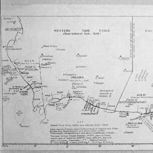
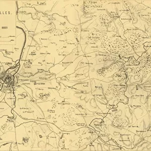
Map of the Battle of Gravelotte, 18 August 1870, (c1872). Creator: R. Walker
. Creator: R. Walker")
![]()
Wall Art and Photo Gifts from Heritage Images
Map of the Battle of Gravelotte, 18 August 1870, (c1872). Creator: R. Walker
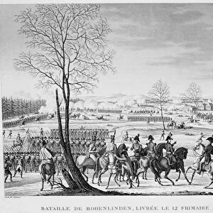
Map of the Battle of Gravelotte, 18 August 1870, (c1872). Map: Drawn under the Superintendance of Captain Hozier, showing the enemy positions. The Battle of Gravelotte, the largest engagement of the Franco-Prussian War, was fought near Gravelotte, a village in Lorraine between the city of Metz and the former French-German frontier. From " The Franco-Prussian War: its causes, incidents and consequences", Volume I, by Captain H M Hozier. [William Mackenzie, London, 1872]
Heritage Images features heritage image collections
Media ID 19778703
© The Print Collector/Heritage Images
1870 1871 Adversary Bamp W Border Enemy Franco Prussian War Front Line Frontier Frontline H M Hozier Henry Montague Henry Montague Hozier Hozier Lines Lorraine Mackenzie Metz Mosel Moselle Prussia Prussian Prussian Army R Walker River Mosel Robert Walker Sir Henry Montagu Hozier Walker William Mackenzie Battle Of Gravelotte Battlefield Gravelotte
FEATURES IN THESE COLLECTIONS
> Arts
> Artists
> W
> Robert Walker
> Arts
> Artists
> W
> Robert White
> Arts
> Artists
> W
> William White
> Europe
> France
> Canton
> Moselle
> Historic
> Battles
> Related Images
EDITORS COMMENTS
This print showcases the "Map of the Battle of Gravelotte, 18 August 1870" created by R. Walker in approximately 1872. The map, drawn under the supervision of Captain Hozier, meticulously depicts the positions of both French and enemy forces during this significant engagement of the Franco-Prussian War. The battle took place near Gravelotte, a village located in Lorraine between Metz and the former French-German frontier. As one examines this historical artifact, it becomes evident that it not only portrays geographical features but also serves as a testament to the intensity and complexity of warfare during that era. The image transports us back to the 19th century battlefield where two formidable adversaries faced off against each other. The lines on this map represent more than just borders; they symbolize a clash between nations with different ideologies and aspirations. Through this remarkable print, we gain insight into how military strategies were employed during this time period. It is an invaluable resource for historians seeking to understand not only specific battles but also broader consequences resulting from them. Thanks to Robert Walker's skillful execution and attention to detail, viewers can appreciate both the artistry behind cartography as well as its practical applications in understanding historical events such as the Battle of Gravelotte.
MADE IN THE USA
Safe Shipping with 30 Day Money Back Guarantee
FREE PERSONALISATION*
We are proud to offer a range of customisation features including Personalised Captions, Color Filters and Picture Zoom Tools
SECURE PAYMENTS
We happily accept a wide range of payment options so you can pay for the things you need in the way that is most convenient for you
* Options may vary by product and licensing agreement. Zoomed Pictures can be adjusted in the Cart.

![The House with the Inscription [left], 1741. Creator: Canaletto](/sq/731/house-inscription-left-1741-creator-21234887.jpg.webp)