Home > Europe > United Kingdom > England > London > Sights > Regents Park
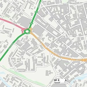
Bromsgrove B60 2 Map

![]()
Wall Art and Photo Gifts from Map Marketing
Bromsgrove B60 2 Map
Postcode Sector Map of Bromsgrove B60 2
Media ID 19965475
Ambleside Way Arundel Road Astley Road Avalon Road Belvoir Road Berkeley Close Blenheim Crescent Brierley Road Bromsgrove Broom Close Carlyle Road Cedar Drive Central Road Chapel Street Chapel Walk Chaucer Road Clive Road College Road Coniston Close Connaught Road Conway Road Corbett Close Coronation Terrace Davenport Drive Derwent Way Drummond Road East Road Garrick Road Granville Close Green Park Road Hanbury Close Hartford Road Hill Lane Hyde Close Kendal Close Kenyon Close Marlborough Avenue Middlefield Road New Road North Road Old Station Road Osborne Road Paxton Close Penshurst Road Pevensey Road Rutland Drive Shaftesbury Close Station Street Stonehouse Road Sunnymead The Crescent Vicarage Close Warwick Avenue Wellington Road West Road Windsor Gardens Windsor Street Paradise Row Regents Park Road
FEATURES IN THESE COLLECTIONS
> Animals
> Fishes
> G
> Garibaldi
> Europe
> Italy
> Veneto
> Padua
> Europe
> United Kingdom
> England
> London
> Sights
> Hyde Park
> Europe
> United Kingdom
> England
> London
> Sights
> Regents Park
> Europe
> United Kingdom
> England
> Rutland
> Related Images
> Map Marketing
> Postcode Sector Maps
> B - Birmingham
> Maps and Charts
> Related Images
MADE IN THE USA
Safe Shipping with 30 Day Money Back Guarantee
FREE PERSONALISATION*
We are proud to offer a range of customisation features including Personalised Captions, Color Filters and Picture Zoom Tools
SECURE PAYMENTS
We happily accept a wide range of payment options so you can pay for the things you need in the way that is most convenient for you
* Options may vary by product and licensing agreement. Zoomed Pictures can be adjusted in the Cart.