Home > Europe > France > Paris > Maps
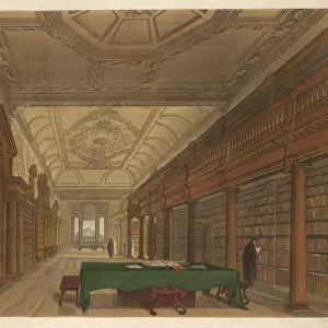
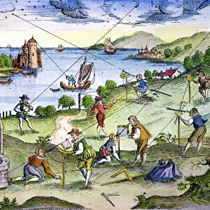
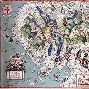
Map of the Atlantic Ocean. 18th century

![]()
Wall Art and Photo Gifts from Mary Evans Picture Library
Map of the Atlantic Ocean. 18th century
Map of the Atlantic Ocean from Newfoundland to Cape Horn. At A Voyage to the South-sea and along the coasts of Chili and Peru, in the years 1712, 1713 and 1714 by Amedee-Franc?ois Frezier (1682-1773). Published in Paris, 1716. Library of Catalonia. Barcelona. Spain
Mary Evans Picture Library makes available wonderful images created for people to enjoy over the centuries
Media ID 14324422
© Thaliastock / Mary Evans
1712 1713 1714 1716 Amedee Atlantic Barcelona Brasil Cape Cartography Catalonia Chili Coasts Continent Drawn Francois Horn Latin Mapping Meridian Peru South Sea Voyage Franc Ois Frezier
FEATURES IN THESE COLLECTIONS
> Africa
> Related Images
> Africa
> South Africa
> Maps
> Africa
> South Africa
> Related Images
> Arts
> Artists
> O
> Oceanic Oceanic
> Europe
> France
> Paris
> Maps
> Europe
> France
> Paris
> Related Images
> Europe
> Italy
> Related Images
EDITORS COMMENTS
This stunning 18th-century map print depicts the Atlantic Ocean from Newfoundland to Cape Horn, as explored during the voyages of Amedee-Francois Frezier between the years 1712 and 1714. The map, titled "A Voyage to the South-sea and along the coasts of Chili and Peru," was published in Paris in 1716. This intricately detailed map showcases the Atlantic Ocean's coastlines of Europe, Africa, and the Americas, including the countries of Brazil, Canada, and Italy. The map also highlights various islands and meridian lines, reflecting the advanced cartography techniques of the time. Frezier's voyages were significant in expanding European knowledge of the South Seas and the coasts of South America. The map's accuracy and level of detail were groundbreaking for the era, making it an invaluable resource for navigators and explorers. This map is now part of the esteemed collection of the Library of Catalonia in Barcelona, Spain, and serves as a testament to the rich history of cartography and exploration during the 18th century.
MADE IN THE USA
Safe Shipping with 30 Day Money Back Guarantee
FREE PERSONALISATION*
We are proud to offer a range of customisation features including Personalised Captions, Color Filters and Picture Zoom Tools
SECURE PAYMENTS
We happily accept a wide range of payment options so you can pay for the things you need in the way that is most convenient for you
* Options may vary by product and licensing agreement. Zoomed Pictures can be adjusted in the Cart.