Home > Arts > Street art graffiti > Digital art > Vector illustrations
Lancaster California US City Street Map

![]()
Wall Art and Photo Gifts from Fine Art Storehouse
Lancaster California US City Street Map
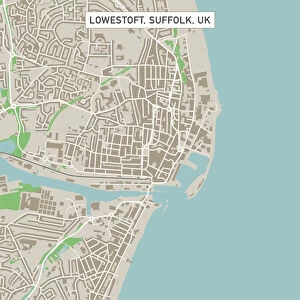
Vector Illustration of a City Street Map of Lancaster, California, USA. Scale 1:60, 000.
All source data is in the public domain.
U.S. Geological Survey, US Topo
Used Layers:
USGS The National Map: National Hydrography Dataset (NHD)
USGS The National Map: National Transportation Dataset (NTD)
Unleash your creativity and transform your space into a visual masterpiece!
Frank Ramspott
Media ID 15055105
© Frank Ramspott, all rights reserved
Aerial View California City Map Computer Graphic Directly Above Downtown District Gray Road Map Text Digitally Generated Image Green Color Lancaster White Color
FEATURES IN THESE COLLECTIONS
> Aerial Photography
> Related Images
> Animals
> Insects
> Hemiptera
> Green Scale
> Animals
> Mammals
> Cricetidae
> California Mouse
> Arts
> Contemporary art
> Digital artwork
> Street art
> Arts
> Landscape paintings
> Waterfall and river artworks
> River artworks
> Arts
> Portraits
> Pop art gallery
> Street art portraits
> Arts
> Street art graffiti
> Digital art
> Digital paintings
> Arts
> Street art graffiti
> Digital art
> Vector illustrations
> Fine Art Storehouse
> Map
> Street Maps
> Fine Art Storehouse
> Map
> USA Maps
> Maps and Charts
> Geological Map
> Maps and Charts
> Related Images
EDITORS COMMENTS
This print showcases a meticulously detailed vector illustration of Lancaster, California's city street map. With a scale of 1:60,000, this artwork provides an intricate depiction of the downtown district, river, lake, and various streets that shape the city's landscape. The design is digitally generated with vibrant colors such as gray, green, blue, and white to enhance its visual appeal. Created by Frank Ramspott using publicly available data from the U. S. Geological Survey (USGS) including The National Map: National Hydrography Dataset (NHD) and The National Map: National Transportation Dataset (NTD), this piece exemplifies expert cartography and precision in mapping techniques. It offers viewers an aerial view directly above Lancaster while incorporating text elements for easy navigation. With no people present in the image itself, the focus remains solely on the artistry behind this computer graphic representation of Lancaster's physical geography. This print serves as both a functional road map for residents and visitors alike while also standing as a visually striking piece of artwork suitable for any space.
MADE IN THE USA
Safe Shipping with 30 Day Money Back Guarantee
FREE PERSONALISATION*
We are proud to offer a range of customisation features including Personalised Captions, Color Filters and Picture Zoom Tools
SECURE PAYMENTS
We happily accept a wide range of payment options so you can pay for the things you need in the way that is most convenient for you
* Options may vary by product and licensing agreement. Zoomed Pictures can be adjusted in the Cart.