Home > Europe > United Kingdom > England > London > Towns > Bermondsey
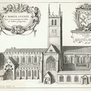
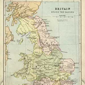
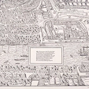
Map of Southwark, 1720, (c1878). Creator: Unknown
. Creator: Unknown")
![]()
Wall Art and Photo Gifts from Heritage Images
Map of Southwark, 1720, (c1878). Creator: Unknown
Map of Southwark, 1720, (c1878). Map showing the village of Southwark on the south bank of the River Thames, in what is now part of greater London. Places shown include the Bank Side, London Bridge, Southwark Cathedral, St Georges Fields and Bermondsey Street. From Old and New London: A Narrative of Its History, Its People, And Its Places. The Southern Suburbs, Volume VI, by Edward Walford. [Cassell, Petter, Galpin & Co. London, Paris & New York, c1878]
Heritage Images features heritage image collections
Media ID 18098262
© The Print Collector / Heritage-Images
Bankside Cassell Company Ltd Edward Edward Walford Galpin Co Galpin Company London Bridge Old And New London Petter Publisher Southwark Southwark Cathedral Walford Bermondsey Street Cassell
FEATURES IN THESE COLLECTIONS
> Arts
> Artists
> W
> George White
> Arts
> Minimalist artwork
> Monochrome artwork
> Fine art
> Arts
> Minimalist artwork
> Monochrome artwork
> Monochrome paintings
> Europe
> France
> Paris
> Maps
> Europe
> United Kingdom
> England
> Greater London
> Related Images
> Europe
> United Kingdom
> England
> London
> Boroughs
> Southwark
> Europe
> United Kingdom
> England
> London
> River Thames
> Europe
> United Kingdom
> England
> London
> Sights
> New River
> Europe
> United Kingdom
> England
> London
> Towns
> Bermondsey
> Europe
> United Kingdom
> England
> Maps
EDITORS COMMENTS
This print showcases a Map of Southwark from 1720, reproduced in the late 19th century. The creator of this intricate map remains unknown, but its historical significance is undeniable. The map depicts the charming village of Southwark nestled on the southern bank of the majestic River Thames, now an integral part of greater London. The detailed illustration highlights various landmarks and areas within Southwark, including Bank Side, London Bridge, Southwark Cathedral, St Georges Fields, and Bermondsey Street. It provides a fascinating glimpse into the past by capturing the essence of life in this bustling city during that era. Originally featured in Edward Walford's renowned publication "Old and New London: A Narrative of Its History, Its People And Its Places". Volume VI - The Southern Suburbs (c1878), this monochrome map offers valuable insights into both geographical features and cultural aspects. It reflects not only the physical layout but also reveals significant religious sites such as churches that played a vital role in shaping society at that time. Preserved through time by Cassell Petter Galpin & Co. , publishers based in London, Paris & New York during the late 19th century; this print serves as a testament to their dedication to preserving history for future generations. As we gaze upon this remarkable piece today courtesy of The Print Collector archive collection; it allows us to appreciate how much has changed while honoring the rich heritage embedded within these ancient streets.
MADE IN THE USA
Safe Shipping with 30 Day Money Back Guarantee
FREE PERSONALISATION*
We are proud to offer a range of customisation features including Personalised Captions, Color Filters and Picture Zoom Tools
SECURE PAYMENTS
We happily accept a wide range of payment options so you can pay for the things you need in the way that is most convenient for you
* Options may vary by product and licensing agreement. Zoomed Pictures can be adjusted in the Cart.