Home > Sheffield City Archives > Maps and Plans > Bowen's County Maps, c. 1777
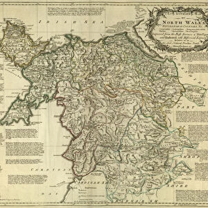
County Map of Glamorganshire, Wales, c. 1777

![]()
Wall Art and Photo Gifts from Sheffield City Archives
County Map of Glamorganshire, Wales, c. 1777
From The Large English Atlas: or, a new set of map of all the counties of England and Wales drawn from the several surveys which have been hitherto been published. With three general maps of England, Scotland and Ireland, from the latest and best authorities, by Emanuel Bowen, Thomas Kitchin and others. London, printed and sold by T. Bowles, [c.1777]
Original at Sheffield Libraries: 912 STF
Sheffield City Archives and Local Studies Library has an unrivalled collection of images of Sheffield, England
Media ID 25491453
© Sheffield City Council - All Rights Reserved
Antique Map Bowens Map County Map Emanuel Bowen Old Map Thomas Kitchin Aberavon Aberdare Barry Caerphilly Cardiff Glamorgan Glamorganshire Llandaff Margam Merthyr Tydfil Port Talbot Rhondda Ruthin Swansea
FEATURES IN THESE COLLECTIONS
> Sheffield City Archives
> Maps and Plans
> Bowen's County Maps, c. 1777
> Sheffield City Archives
> Maps and Plans
> Maps of Wales
EDITORS COMMENTS
This antique map, titled "County Map of Glamorganshire, Wales, c. 1777" is a fascinating glimpse into the past. Created by renowned cartographers Emanuel Bowen and Thomas Kitchin, it showcases the intricate details of Glamorgan County during the late 18th century. The map captures the essence of this historic region with its vibrant cities and picturesque landscapes. From bustling Cardiff to charming Swansea, every town and village is meticulously depicted, giving us a sense of what life was like in this part of Wales over two centuries ago. As we explore the map further, we discover notable landmarks such as Aberavon's sandy shores and Aberdare's lush valleys. The industrial heritage comes alive through symbols representing Aberdulais' ironworks and Merthyr Tydfil's coal mines. Each symbol tells a story of growth and progress that shaped these communities. With its elegant typography and delicate illustrations, this print from "The Large English Atlas" transports us back to an era when maps were not just navigational tools but works of art themselves. It serves as a testament to the skillful craftsmanship that went into creating such detailed representations before modern technology took over. Preserved at Sheffield Libraries since its creation in 1777, this historical gem offers a unique window into Glamorganshire's rich history for all who appreciate both cartography and Welsh heritage alike.
MADE IN THE USA
Safe Shipping with 30 Day Money Back Guarantee
FREE PERSONALISATION*
We are proud to offer a range of customisation features including Personalised Captions, Color Filters and Picture Zoom Tools
SECURE PAYMENTS
We happily accept a wide range of payment options so you can pay for the things you need in the way that is most convenient for you
* Options may vary by product and licensing agreement. Zoomed Pictures can be adjusted in the Cart.