Home > Fine Art Storehouse > The Magical World of Illustration > Palmer Illustrated Collection
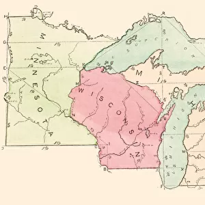
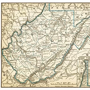
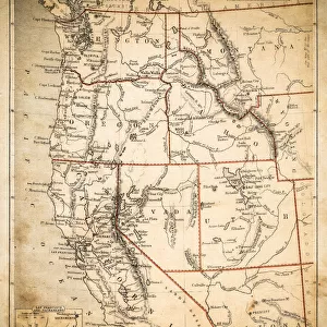
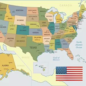
States USA map 1875

![]()
Wall Art and Photo Gifts from Fine Art Storehouse
States USA map 1875
The Independent Course Comprehensive Geography by James Monteith, A.S. Barnes & Co, New York & Chicago 1875
Unleash your creativity and transform your space into a visual masterpiece!
THEPALMER
Media ID 13612171
© This content is subject to copyright
Globe Navigational Equipment Illinois Iowa Kansas Missouri North America Paper Drawing Art Product
FEATURES IN THESE COLLECTIONS
> Fine Art Storehouse
> The Magical World of Illustration
> Palmer Illustrated Collection
> Fine Art Storehouse
> Map
> Historical Maps
> Fine Art Storehouse
> Map
> USA Maps
EDITORS COMMENTS
This print takes us back in time to the year 1875, showcasing an intricately detailed map of the United States of America. Titled "States USA Map 1875" this vintage piece is a reproduction from James Monteith's renowned book, "The Independent Course Comprehensive Geography". Published by A. S. Barnes & Co in New York and Chicago, this map offers a fascinating glimpse into the geography of that era. The image depicts various states such as Illinois, Iowa, Kansas, and Missouri with exceptional precision. The artist has skillfully captured every intricate detail through engraving and etching techniques on paper. This antique cartographic masterpiece showcases not only the physical geography but also serves as a navigational tool for globetrotters during that time. "The Independent Course Comprehensive Geography" was widely regarded as an authoritative source for geographical knowledge during its period. Its influence can be seen through this meticulously crafted illustration which continues to captivate art enthusiasts even today. Displayed horizontally, this drawing art product evokes nostalgia while serving as a testament to the rich history of cartography. With its timeless appeal and attention to detail, THEPALMER has successfully brought forth a stunning representation of American geography from over a century ago.
MADE IN THE USA
Safe Shipping with 30 Day Money Back Guarantee
FREE PERSONALISATION*
We are proud to offer a range of customisation features including Personalised Captions, Color Filters and Picture Zoom Tools
SECURE PAYMENTS
We happily accept a wide range of payment options so you can pay for the things you need in the way that is most convenient for you
* Options may vary by product and licensing agreement. Zoomed Pictures can be adjusted in the Cart.