Home > Arts > Artists > T > John Tallis
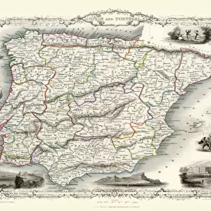
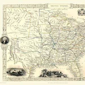
Old Map of Mexico, California & Texas 1851by John Tallis

![]()
Wall Art and Photo Gifts from MapSeeker
Old Map of Mexico, California & Texas 1851by John Tallis
A fine facimile artworked from an antique original map of Mexico, California and Texas, issued as part of the 1851 edition of John Tallis and Companys " The Illustrated Atlas and Modern History of the World"
Welcome to the Mapseeker Image library and enter an historic gateway to one of the largest on-line collections of Historic Maps, Nostalgic Views, Vista's and Panorama's from a World gone by.
Media ID 20347465
© Mapseeker Publishing Ltd
John Tallis John Tallis Map Tallis Map
FEATURES IN THESE COLLECTIONS
> Animals
> Mammals
> Cricetidae
> California Mouse
> Arts
> Artists
> T
> John Tallis
> Maps and Charts
> Related Images
> Maps and Charts
> World
> MapSeeker
> Maps of the Americas
> Maps of Central and South America
> MapSeeker
> Maps of the Americas
> Maps of the United States of America
> North America
> Mexico
> Maps
> North America
> Mexico
> Related Images
> North America
> United States of America
> Related Images
EDITORS COMMENTS
This print showcases an exquisite piece of history - the "Old Map of Mexico, California & Texas 1851" by John Tallis. A true work of art, this fine facsimile artwork has been meticulously reproduced from an antique original map that was part of the renowned 1851 edition of John Tallis and Company's "The Illustrated Atlas and Modern History of the World". Transporting us back in time, this map offers a glimpse into the intricate cartographic knowledge and artistic craftsmanship prevalent during the mid-19th century. With its delicate details and ornate embellishments, it serves as a testament to both Tallis' skill as a cartographer and Rapkin's talent as an engraver. The map itself encompasses not only Mexico but also California and Texas, regions that were undergoing significant transformations during this era. It provides a window into how these territories were perceived at the time - their borders, cities, rivers, mountains, and other geographical features carefully delineated. As we admire this remarkable piece of historical documentation, we are reminded of the importance placed on maps in understanding our world's past. The Old Map of Mexico allows us to explore how perceptions have changed over time while appreciating the timeless beauty captured within its intricately drawn lines.
MADE IN THE USA
Safe Shipping with 30 Day Money Back Guarantee
FREE PERSONALISATION*
We are proud to offer a range of customisation features including Personalised Captions, Color Filters and Picture Zoom Tools
SECURE PAYMENTS
We happily accept a wide range of payment options so you can pay for the things you need in the way that is most convenient for you
* Options may vary by product and licensing agreement. Zoomed Pictures can be adjusted in the Cart.