Home > Arts > Artists > C > Craig Craig
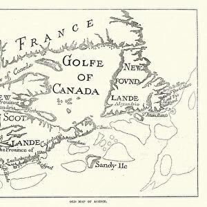
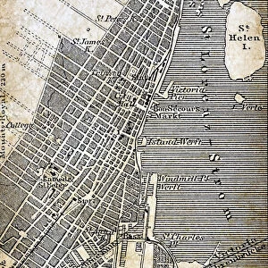
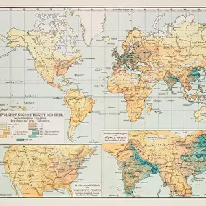
Victorian Map of Eastern Canada Circa 1850

![]()
Wall Art and Photo Gifts from Fine Art Storehouse
Victorian Map of Eastern Canada Circa 1850
Engraved illustration of a Map of Eastern Canada in counties from Iconographic Encyclopedia of Science, Literature and Art, Published in 1851. Copyright has expired on this artwork. Digitally restored
Unleash your creativity and transform your space into a visual masterpiece!
bauhaus1000
Media ID 13666961
© Craig McCausland
1850 1859 66864 78279 Canada Canadian Culture Chart Copperplate Engraving Country Geographic Area Diagram French Culture Image Created 1850 1859 Isolated Journey Montreal North America Ornate Plan Quebec World Map Drawing Art Product Image Created 19th Century Multi Colored New Brunswick Canada Victorian Style
FEATURES IN THESE COLLECTIONS
> Arts
> Artists
> C
> Craig Craig
> Arts
> Contemporary art
> Photography
> Digital art
> Arts
> Literature
> Illustration
> Arts
> Literature
> Arts
> Street art graffiti
> Digital art
> Digital paintings
> Fine Art Storehouse
> Map
> Historical Maps
> Maps and Charts
> Related Images
> Maps and Charts
> World
EDITORS COMMENTS
This beautifully restored print showcases a Victorian Map of Eastern Canada circa 1850, offering a fascinating glimpse into the region's rich history and cultural heritage. The intricately engraved illustration, originally featured in the Iconographic Encyclopedia of Science, Literature and Art published in 1851, captures the essence of 19th-century cartography with its ornate details and woodcut style. The map takes us on a visual journey through time, depicting the counties of Eastern Canada in vibrant multi-colored hues. From bustling cities like Montreal to charming towns nestled amidst picturesque landscapes, this historical artifact provides valuable insights into Canadian culture during the Victorian era. As we explore this piece of art, we are reminded of the significant role that travel and tourism played even back then. The map not only serves as a navigational tool but also sparks our imagination by highlighting famous landmarks and important destinations across Eastern Canada. With its copperplate engraving technique and meticulous craftsmanship, this print exemplifies the artistic mastery prevalent during the mid-19th century. Its horizontal composition allows us to appreciate every intricate detail while drawing us deeper into an era long gone. Whether you are a history enthusiast or simply captivated by vintage aesthetics, this Victorian Map is sure to be an exquisite addition to any collection. It offers both a window into our past and an opportunity for exploration within one frame – truly embodying the spirit of art as well as cultural preservation.
MADE IN THE USA
Safe Shipping with 30 Day Money Back Guarantee
FREE PERSONALISATION*
We are proud to offer a range of customisation features including Personalised Captions, Color Filters and Picture Zoom Tools
SECURE PAYMENTS
We happily accept a wide range of payment options so you can pay for the things you need in the way that is most convenient for you
* Options may vary by product and licensing agreement. Zoomed Pictures can be adjusted in the Cart.