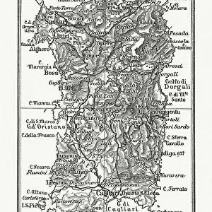
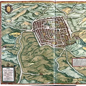
Map of Sardinia by G. H. Davis

![]()
Wall Art and Photo Gifts from Mary Evans Picture Library
Map of Sardinia by G. H. Davis
A contour map of Sardinia, showing airfields and seaplane bases during the Second World War. The island was experiencing concentrated bombing by the Allied Strategic Air Force. Date: 1943
Mary Evans Picture Library makes available wonderful images created for people to enjoy over the centuries
Media ID 14133381
© Illustrated London News Ltd/Mary Evans
1943 Airfield Airfields Allied Bases Bombing Concentrated Contour Davis Maps Mediterranean Mountainous Sardinia Seaplane Strategic Tyrrhenian Base
EDITORS COMMENTS
This evocative map print by G.H. Davis depicts the contoured terrain of Sardinia, an Italian island in the Mediterranean Sea, during the tumultuous year of 1943. The map serves as a historical record of a pivotal moment in World War II when the Allied Strategic Air Force intensely targeted the island with bombing raids. Sardinia's strategic location in the Tyrrhenian Sea made it a valuable asset for both the Axis and Allied powers. Airfields and seaplane bases scattered across the island are clearly marked on the map, providing evidence of the military significance of this mountainous and rugged landscape. The island's natural features, including its mountain ranges, contrast sharply with the man-made structures of the military installations. The year 1943 was a turning point in the Mediterranean theater of the war. Allied forces, seeking to gain control of the Mediterranean Sea and weaken the Axis powers, launched a series of concentrated bombing campaigns against Sardinia. The island's airfields and seaplane bases were primary targets, as they provided crucial support for the Axis forces in the region. This map offers a unique glimpse into the wartime history of Sardinia, revealing the strategic importance of the island during the Second World War. The intricate details of the contours, airfields, and seaplane bases provide a testament to the meticulous planning and execution of military operations during this period. The map also serves as a poignant reminder of the human impact of war and the sacrifices made by those who lived through it.
MADE IN THE USA
Safe Shipping with 30 Day Money Back Guarantee
FREE PERSONALISATION*
We are proud to offer a range of customisation features including Personalised Captions, Color Filters and Picture Zoom Tools
SECURE PAYMENTS
We happily accept a wide range of payment options so you can pay for the things you need in the way that is most convenient for you
* Options may vary by product and licensing agreement. Zoomed Pictures can be adjusted in the Cart.