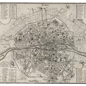
The War: Fortifications in Paris

![]()
Wall Art and Photo Gifts from Mary Evans Picture Library
The War: Fortifications in Paris
Map showing the fortifications in Paris during the Franco-Prussian War. Date: 1870
Mary Evans Picture Library makes available wonderful images created for people to enjoy over the centuries
Media ID 14131945
© Illustrated London News Ltd/Mary Evans
Fortification Fortifications Franco Maps Prussian Wars
EDITORS COMMENTS
This print showcases an intricately detailed map depicting the fortifications of Paris during the Franco-Prussian War in 1870. The map, a testament to the meticulous cartographic skills of its creator, offers a fascinating glimpse into the strategic military landscape of one of history's most significant conflicts. The Franco-Prussian War, which lasted from July to September 1870, was a pivotal moment in European history. The conflict arose from the long-standing tensions between France and Prussia, fueled by the latter's desire for territorial expansion and the former's determination to maintain its status as a major European power. The map reveals the extensive fortifications that encircled Paris, the heart of the French Empire. The city's defenses were a formidable obstacle for the invading Prussian forces, who were ultimately successful in breaching the walls at several points, most notably at the Battle of Sedan. The fall of Paris in January 1871 marked the end of the war and the beginning of a new era for France, which would see the country undergo significant political and social changes. The map also highlights the strategic locations of key military installations, such as forts, batteries, and redoubts, that played crucial roles in the defense of Paris. The intricate network of roads, railways, and waterways that crisscross the map provide insight into the logistical challenges faced by both sides during the war. This print is a valuable historical resource, offering a unique perspective on the military and strategic aspects of the Franco-Prussian War. Its intricate details and meticulous accuracy make it an essential addition to any collection of historical maps or military history.
MADE IN THE USA
Safe Shipping with 30 Day Money Back Guarantee
FREE PERSONALISATION*
We are proud to offer a range of customisation features including Personalised Captions, Color Filters and Picture Zoom Tools
FREE COLORIZATION SERVICE
You can choose advanced AI Colorization for this picture at no extra charge!
SECURE PAYMENTS
We happily accept a wide range of payment options so you can pay for the things you need in the way that is most convenient for you
* Options may vary by product and licensing agreement. Zoomed Pictures can be adjusted in the Cart.