Home > Science > Space Exploration > Planets > Earth
Africa, satellite image

![]()
Wall Art and Photo Gifts from Science Photo Library
Africa, satellite image
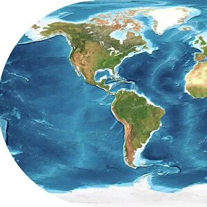
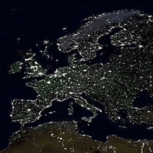
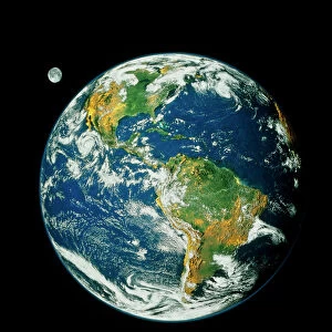
Africa. Satellite image of the Earth centred on Africa. Clouds are white, oceans are blue and land is green and brown. Also seen are Europe (top) Asia (upper right), the Indian Ocean (right), the Southern Ocean (bottom), the South Atlantic Ocean (lower left), South America (left) and the North Atlantic (upper left). This image was produced by combining data from the Defense Meteorological Satellite Program (DMSP), NOas POES and Nimbus 7 satellites and the MODIS instrument on board NASAs Terra satellite
Science Photo Library features Science and Medical images including photos and illustrations
Media ID 1705023
© PLANETARY VISIONS LTD/SCIENCE PHOTO LIBRARY
Africa Circle Circular Cloud Cloud Cover Clouds Cloudy Combined Data Continent Continents Day Time Defense Meteorological Dmsp Earth Observation Earth Science From Space Globe Indian Ocean Land Land Cover Moderate Resolution Imaging Modis Nasa Nimbus 7 Noaa North Atlantic Planetary Poes Polar Orbiter Region Round Satellite Satellite Image Satellite Program Satellites Sciences South Atlantic Southern Ocean Spectroradiometer Sphere Spherical Terra Topographical Topography Vegetation World Arth
FEATURES IN THESE COLLECTIONS
> Africa
> Related Images
> Africa
> South Africa
> Related Images
> Arts
> Artists
> O
> Oceanic Oceanic
> Asia
> Related Images
> Europe
> France
> Canton
> Landes
> Europe
> Related Images
> North America
> Related Images
> Science Photo Library
> Aerial and Satellite
> Science
> Space Exploration
> Planets
> Earth
> Science
> Space Exploration
> Related Images
> Science
> Space Exploration
> Satellite Imagery
EDITORS COMMENTS
This stunning satellite image captures the beauty and diversity of Africa, showcased at the center of our Earth. The vibrant colors depict a breathtaking view of our planet's natural elements - white clouds, blue oceans, and green and brown land. As we explore this image further, other continents come into view: Europe crowns the top, Asia stretches towards the upper right corner, while South America graces the left side. The Indian Ocean lies to the right, with the Southern Ocean below it and the South Atlantic Ocean on its lower left. A collaboration between various satellites including Defense Meteorological Satellite Program (DMSP), NOas POES, Nimbus 7 satellites, and NASA's Terra satellite with MODIS instrument onboard has produced this remarkable composite image. It showcases not only Africa but also provides us with a glimpse of different regions across our globe. The intricate details captured by these advanced technologies allow us to observe Earth's topography in great detail - from lush vegetation to vast bodies of water. This photograph serves as a reminder of how interconnected our world is; it highlights both its fragility and resilience. As we marvel at this awe-inspiring snapshot taken from space, let us appreciate the wonders that lie within our own planet.
MADE IN THE USA
Safe Shipping with 30 Day Money Back Guarantee
FREE PERSONALISATION*
We are proud to offer a range of customisation features including Personalised Captions, Color Filters and Picture Zoom Tools
SECURE PAYMENTS
We happily accept a wide range of payment options so you can pay for the things you need in the way that is most convenient for you
* Options may vary by product and licensing agreement. Zoomed Pictures can be adjusted in the Cart.